Yukon Mountain Biking: Part 2 - Kluane National Park
Kluane National Park – Cottonwood Loop, Auriol Trail and the Alsek Trail
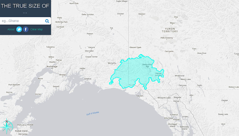
Kluane National Park in southwest Yukon is vast being 22,013 Sq km in size and hosting Mt. Logan; Canada’s highest peak at 6050m. The park is so big that you can’t see anything even as high as Mt. Logan from the closest town (Haines Junction) or the roads and/or popular trails in the area. The National Park doesn’t even extend into the Kluane and St. Elias Icefields which extend west into Alaska and south to British Columbia.
To give an idea of scale you can fit the entire country of Switzerland into the National Park and the contiguous icefields. The permanent population of Kluane National Park and the icefields is ZERO.
Perhaps the lack of population pressure explains why Kluane National Park is relatively friendly to mountain-biking (despite lip service Parks Canada is less then progressive when allowing mtb access to trails). Another reason may be that the Park’s Superintendant is knowledgeable about mtbs (he was a past-president of the Whitehorse Contagious Mountain Bike Club). Regardless of reasons, a surprising proportion of Kluane’s trails are OK’ed for biking. We sampled three of them; the Cottonwood loop, the Auriol and the Alsek trails
![Cottonwood Loop Auriol and Alsek trails]() The vastness and emptiness of the Kluane Icefields and the Ste Elias Range as compared to Switzerland, the blue outline.
The vastness and emptiness of the Kluane Icefields and the Ste Elias Range as compared to Switzerland, the blue outline.
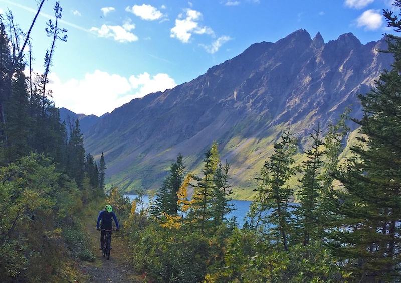
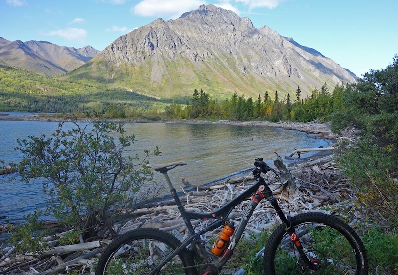
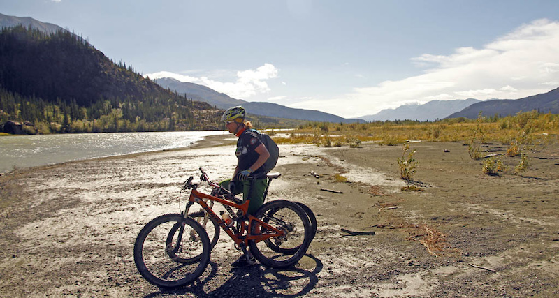
![Cottonwood Loop Auriol and Alsek trails]() Kathleen Lake on the Cottonwood Loop
Kathleen Lake on the Cottonwood Loop
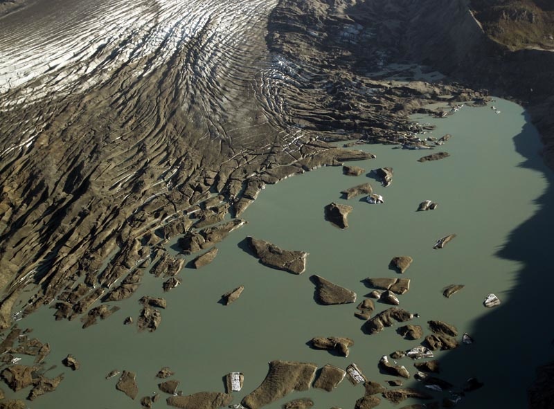
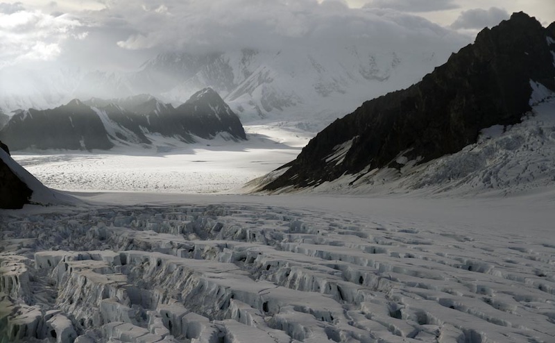
![For a story about biking in Kluane National Park]() The toe of the Kaskawulsh Glacier in the Kluane Icefields
The toe of the Kaskawulsh Glacier in the Kluane Icefields
________________________________________________________________________________
The Cottonwood Loop
It shouldn’t be surprising that one of the mountain bike rides you can do in Kluane is big, long, and committing. The Cottonwood loop circumnavigates the Dalton range which in itself are just foothills and mere pimples on the face of the Kluane Icefields and St Elias Range.
At 85km the Cottonwood loop is more then just a pleasant ramble in the backwoods. It quickly gains the alpine and stays there for a long time being a mix of double track (where you can cover ground quickly), some single track and the last 7km/2 hours a hike-a-bike on a trail beside Kathleen Lake. This ride has amazing views so is best done on a clear day, or as recommended in the Travel Yukon page as a multiday hike or ski. We don’t remember how many creeks we crossed; whether it’s one or one hundred, your feet will be wet. If the first creek is difficult to cross, turn back! That first creek crossing is relatively easy so it will be a harbinger of what is to come. Don’t be that person who took 23 hours car to car and who got washed and tomahawked downstream when attempting to cross a very flooded Victoria Creek. The best time to do this trail is when the creeks are running low. This will likely mean a later-in-the season start around late August to mid September. Bring lots of food, keep moving and you should get out before dark!
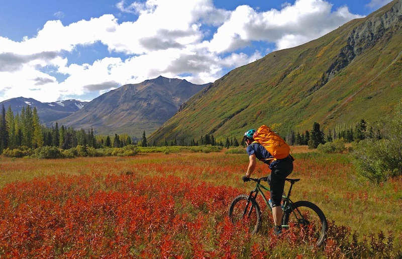
![Cottonwood Loop Auriol and Alsek trails]() Fireweed meadows with a view of the Auriol Range
Fireweed meadows with a view of the Auriol Range
Check with Parks Canada before you go. This is grizzly bear central and it's good to know where in particular you will want to have your heads up. Also Parks does conduct brushing expeditions (as does the CMBC) but it's also good to know if the trail is bushy so you can plan accordingly.
We started our day’s trip by leaving Whitehorse then driving 2hours to Kluane, parking at Mush Lake Rd trailhead. We arranged to have our car brought to the Kathleen Lake trailhead at the end of the day by another group who was doing the Cottonwood the next day. You could ride ~10km on the road if you really want to to complete the loop or if you’re into gratuitious pain. You can also arrange a boat pick up at Kathleen Lake to miss the joy of a two hour hike-a-bike which completes the ride (Boreale Explorers may be able to arrange this for you but you will need a sat phone beforehand to communicate with the boat).
________________________________________________________________________________
![Cottonwood Loop Auriol and Alsek trails]() Trim map of the trail.
Trim map of the trail.
![Cottonwood Loop Auriol and Alsek trails]() Amazing views of the Dalton range on the Cottonwood trail.
Amazing views of the Dalton range on the Cottonwood trail.
________________________________________________________________________________
For the remainder of the trip description reference the Kluane National Parks description which is referenced in this article (the wording can disappear from their website so is reproduced)
- The first section (16 km) of the Cottonwood Trail follows the Mush Lake Road, a 22 km one lane, four-wheel drive road joining the Haines highway to Mush Lake.
- Km 0 – 5.5: The trail is flat and easy to follow.
- Km 5.5 – 7.5: At the first trail junction, take the left trail (headed west) as the right trail (veering north) leads to Shorty Creek. From this junction for about a kilometer, you will cross the many channels of Alder Creek.
- Km 7.5 – 12.0: After Alder Creek the trail stays high and dry, crossing numerous small hills and low sections along the north side of the valley.
- Km 12.0 – 16.5: A small footbridge hidden on the north side of the road conveniently bridges the unnamed creek. There are bear claw marks on the trees around here, this area and the old primitive campsite at Dalton Creek are not recommended for camping due to bear activity. Dalton Creek can be crossed via the footbridge on the north side of the road.
- Km 16.5 – 21.5: The road branches, the left trail continues west climbing steadily for 5 km to Mush Lake. Take the right branch turning uphill and to the north. The Cottonwood Trail climbs steadily for the next 5 km, travelling through a spruce forest alongside Dalton Creek. The trail emerges at a meadow; this is the old Dalton Camp that is not recommended for camping. There is an abundance of bear sign in the area; it is obviously a popular travel route for wildlife. If it is near the end of the day and you are in search of a place to camp, your best alternative to continuing on, is to head west following the meadows and find a camp site that you are comfortable with, there seems to be less bear signage in this direction, as it appears to be less of a travel route. If you are continuing on the trail, head right (north) at the primitive Dalton Camp, the trail climbs to a beautiful alpine pass.
- Km 21.5 – 26.7: The alpine pass is known as Dalton Pass. The trail traces the west side of Dalton Creek, crossing many smaller creeks along the way. In spring this area is very wet and not suitable for camping. Grizzly bear, moose and ptarmigan are common to the area, however other wildlife sightings may include fox, coyote, wolves, wolverines, sheep, goats, marmots, pikas, ground squirrels, golden eagles, and smaller birds.
![Cottonwood Loop Auriol and Alsek trails]() Mush Lake Road trailhead
Mush Lake Road trailhead
![Cottonwood Loop Auriol and Alsek trails]() Creek crossing #1 on Alder Creek. If this is difficult to cross, turn back! It will not improve
Creek crossing #1 on Alder Creek. If this is difficult to cross, turn back! It will not improve
![Cottonwood Loop Auriol and Alsek trails]() Why wring out your socks? They’re only going to get wet again! Excuse to rest maybe? Lighten the Shimano shoes maybe?
Why wring out your socks? They’re only going to get wet again! Excuse to rest maybe? Lighten the Shimano shoes maybe?
![Cottonwood Loop Auriol and Alsek trails]()
![Cottonwood Loop Auriol and Alsek trails]() Typical double track for the first 35km or so.
Typical double track for the first 35km or so.
![Cottonwood Loop Auriol and Alsek trails]() Creek crossing #10 or so… at the first Dalton Pass
Creek crossing #10 or so… at the first Dalton Pass
![Cottonwood Loop Auriol and Alsek trails]() Descending to the second Dalton Pass
Descending to the second Dalton Pass
________________________________________________________________________________
Cottonwood loop description continues …
- Km 26.7 – 33.0: From the pass the trail continues downhill, roughly following Shrikes Creek. After a steep switchback, the trail crosses upper Victoria Creek. Posts on either side of Victoria Creek mark the best crossing areas (Victoria Creek is crossed a second time, where it empties into Louise Lake at km 67).
- Km 33.0 – 35.7: The trail heads west (upstream) along Victoria Creek, and is easy to follow up to km 35.7. Although the road continues, follow the trail that cuts up to the right. This is the only way out of the valley!
- Km 37.5 – 39.3: You will gain 150 M (500′) in elevation along this section of the trail as you cross the second mountain pass of your hike. Posts or stone markers mark the trail. If you have any extra time, this is a nice area to explore further.
________________________________________________________________________________
![Cottonwood Loop Auriol and Alsek trails]() Shrike Creek
Shrike Creek
![Cottonwood Loop Auriol and Alsek trails]() On the descent from the second Dalton Pass and crossing Cottonwood Creek
On the descent from the second Dalton Pass and crossing Cottonwood Creek
________________________________________________________________________________
Cottonwood loop description continues …
- Km 39.3 – 41.8: You are now in the Cottonwood Valley. The trail winds downhill into groves of balsam poplar trees and wildflower meadows.
- Km 41.8 – 46.6: This is the halfway point of the trail. Cross the smaller creek that joins Cottonwood Creek, however it is best to remain on the left side of Cottonwood Creek, particularly during high water. Watch for a marker downstream that indicates where the trail crosses the creek and follows a series of meadow thickets. It will continue through these meadows until it emerges once again at Cottonwood Creek (km 46.6). When the creek is low, you may be able to walk down the creek bed. It is recommended to obtain water before reaching the designated campsite, as the meadows are dry and water may not be available. Kilometre 47 is the beginning of a 36 km stretch of the trail where camping in designated campsites is mandatory.
- Km 46.6 – 49.0: The trail now turns north and wanders through a spruce and willow forest for about l km before opening up in a very large meadow. The first designated camping area is located in this two-kilometre stretch of meadow (km 47 – km 49). The next camping area is also a designated site and is 18-20 km away at Lower Victoria Creek. There is no camping allowed between these two areas. You may notice a long “bear stomp” that approaches and leaves one of the last spruce trees leading into the meadow. A bear stomp is an area of indented footprints made by a bear (or several bears) following in the same tracks over time. Stomps often lead to scratching trees, where the bears rub and claw.
________________________________________________________________________________
![Cottonwood Loop Auriol and Alsek trails]() The cottonwoods, the namesake of the trail. Even though this is probably Cotton Grass
The cottonwoods, the namesake of the trail. Even though this is probably Cotton Grass
![Cottonwood Loop Auriol and Alsek trails]()
![Cottonwood Loop Auriol and Alsek trails]() Climbing out of the Cottonwood valley and towards Cottonwood Pass
Climbing out of the Cottonwood valley and towards Cottonwood Pass
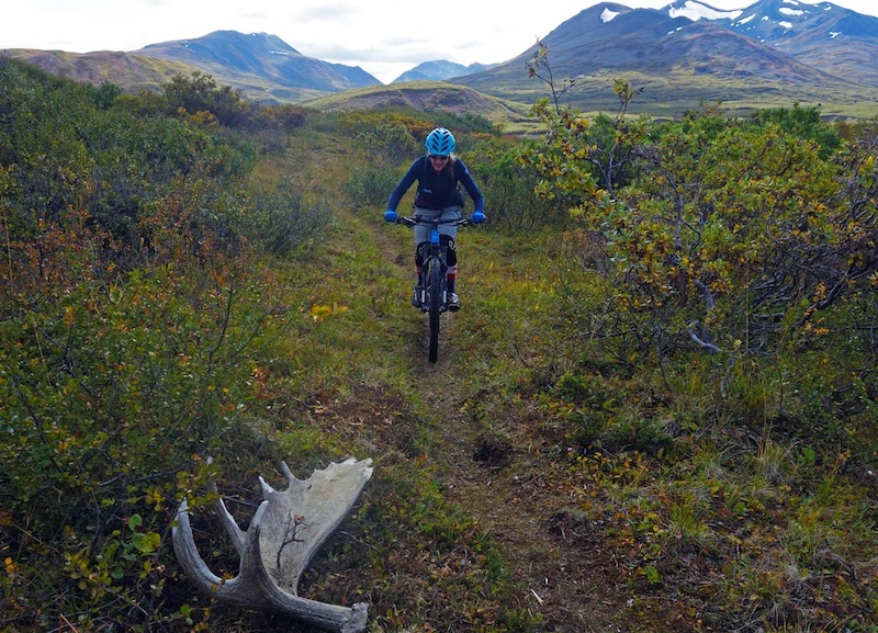
![Cottonwood Loop Auriol and Alsek trails]() Single track and Moose tracks
Single track and Moose tracks
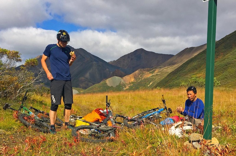
![Cottonwood Loop Auriol and Alsek trails]() Lunch time! Eat Lots on this ride! This was at about the 43km mark.
Lunch time! Eat Lots on this ride! This was at about the 43km mark.
![Cottonwood Loop Auriol and Alsek trails]()
![Cottonwood Loop Auriol and Alsek trails]() The ridiculously scenic descent of Cottonwood pass to subalpine meadows and valleys
The ridiculously scenic descent of Cottonwood pass to subalpine meadows and valleys
![Cottonwood Loop Auriol and Alsek trails]() Fireweed goes nuts in its crimson red at this time of the year
Fireweed goes nuts in its crimson red at this time of the year
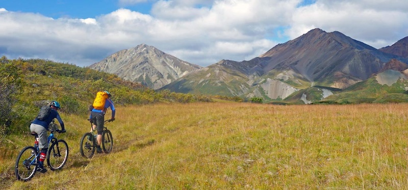
![Cottonwood Loop Auriol and Alsek trails]() We came from wayyyy back there rounding one range and still have a long way to go to traverse another two ranges
We came from wayyyy back there rounding one range and still have a long way to go to traverse another two ranges
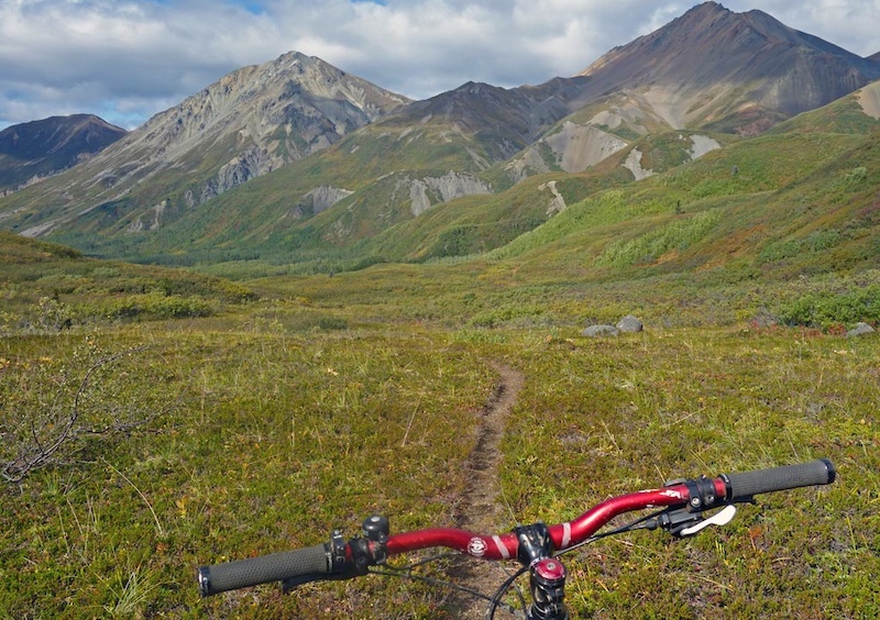
![Cottonwood Loop Auriol and Alsek trails]() The view now opens up towards the inner foothills of the Kluane Icefields and the Auriol Range
The view now opens up towards the inner foothills of the Kluane Icefields and the Auriol Range
![Cottonwood Loop Auriol and Alsek trails]() Singletrack enduro slaloms Fireweed fields. The view keeps getting more and more magnificent as the Auriol Range and the Alsek drainage splits the land
Singletrack enduro slaloms Fireweed fields. The view keeps getting more and more magnificent as the Auriol Range and the Alsek drainage splits the land
________________________________________________________________________________
Cottonwood loop description continues …
- Km 49.0 – 52.4: The 49.0 km signpost stands out in the meadow. There is no camping from this point (km 49) until Victoria Creek at km 67. The trail leaves the meadow and turns right along the side hill to avoid wet areas. The section leaving the meadow may be spongy and wet however conditions dry up as the trail climbs to the abandoned mining road leading to Kathleen Lake. During mid to late summer Sheperdia canadensis (Soapberry or Buffalo berry) is abundant from this section of trail through to Kathleen Lake. Be vigilant in making noise and very bear aware.
- Km 52.4 – 55.7: The trail crosses a creek and the road continues down through an old spruce forest until you arrive at the Johobo mine site.
- Km 55.7 – 57.3: Look for the remains of the abandoned Johobo mine. The mine operated until the early 60′s. Bornite, a purplish coloured copper ore found in small veins in volcanic rocks, was excavated in the mine. The small mountain on the right contains the entrance to the mineshaft. The cleared area offers great opportunity to see wildlife tracks.
________________________________________________________________________________
![Cottonwood Loop Auriol and Alsek trails]() Grass fields add a very Chilcotin feel
Grass fields add a very Chilcotin feel
![Cottonwood Loop Auriol and Alsek trails]() A trail marker at KM 49! We’re not lost!
A trail marker at KM 49! We’re not lost!
________________________________________________________________________________
Cottonwood loop description continues …
- Km 57.3 – 67.1: The next l0 km follows a side hill that overlooks Louise Lake, eventually arriving at the lakeshore and lower Victoria Creek alluvial fan.
- Km 67.1 – 71.3: Kilometre 67 marks the location of the second designated campsite. For the second time on the trip you’ll cross Victoria Creek, however exercise caution as the volume is greater and the flow swifter. It may be wise to spend the night and cross early in the morning when water levels are lower. Search up and downstream for a spot where the stream is wide and shallow. There are signposts on either side of the creek that lead back to the trail.
- Km 71.3 -74.2: There is one additional designated campsite approximately 4 km east of Victoria Creek. This site is located along the shore of Kathleen Lake where the trail crosses an unnamed creek at approximately km 71.3. Pick the site with the best visibility next to the lakeshore rather than in the treed area near the trail. This is the last designated camping site before the Kathleen Lake trailhead. Plan to hike the remainder of the trail in one day (about 12 km). The trail continues along the lakeshore and meets a peninsula at km 74.2. A rockslide occurred at km 72. It is highly recommended to carefully skirt around the slide.
________________________________________________________________________________
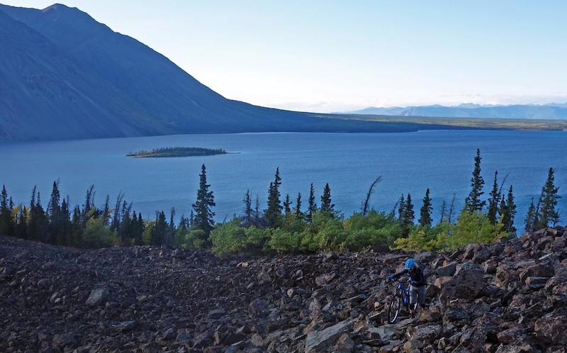
![Cottonwood Loop Auriol and Alsek trails]() Louise lake, rounding the N-S bend of the loop and down to the homestretch. Two ranges down, one more to go!
Louise lake, rounding the N-S bend of the loop and down to the homestretch. Two ranges down, one more to go!
![Cottonwood Loop Auriol and Alsek trails]() Victoria Creek and Louise Lake confluence. This is a key danger point. People have spent literally hours finding a safe crossing on this creek. Guess its better then a 75km backtrack.
Victoria Creek and Louise Lake confluence. This is a key danger point. People have spent literally hours finding a safe crossing on this creek. Guess its better then a 75km backtrack.
![Cottonwood Loop Auriol and Alsek trails]() Now on Kathleen Lake looking at Mt Worthington. A boat pickup is possible at this point which is at approximately km 71.5.
Now on Kathleen Lake looking at Mt Worthington. A boat pickup is possible at this point which is at approximately km 71.5.
![Cottonwood Loop Auriol and Alsek trails]() Last bit of navigable trail looks to Kings Throne proper at approximately km 77. Keep moving as you still have 2.5 hours to go
Last bit of navigable trail looks to Kings Throne proper at approximately km 77. Keep moving as you still have 2.5 hours to go
________________________________________________________________________________
Cottonwood loop description continues …
- Km 74.2-77.9: Goat Creek campsite has been permanently closed due to frequent bear activity in the area. The trail crosses Goat Creek, a creek that is usually narrow and swift so you may need to scope a good crossing spot. The trail climbs onto and over a rock glacier just past Goat Creek, this section is single track with several switchbacks, rock Cairns mark the way.
- Km 77.9 – 81.0: The trail skirts the slope above Kathleen Lake, crossing a few avalanche paths before descending to the King’s Throne trail junction (marked with a post). The trail veering right climbs the Kings Throne, do not take this trail but continue straight along Kathleen Lake.
- Km 81.0 – 82.7: The trail winds along Kathleen Lake eventually opening up on an old mining road and ends at the Kathleen Lake Day Use Area, 27 km (17 mi) south of Haines Junction.
________________________________________________________________________________
![Cottonwood Loop Auriol and Alsek trails]() Trek along Kathleen Lake as the hike-a-bike starts for good times
Trek along Kathleen Lake as the hike-a-bike starts for good times
![Cottonwood Loop Auriol and Alsek trails]()
![Cottonwood Loop Auriol and Alsek trails]()
![Cottonwood Loop Auriol and Alsek trails]() Completes the trip. Sitting in a boat on that beautiful lake below, eating bon bons and having a beer would be cheating!
Completes the trip. Sitting in a boat on that beautiful lake below, eating bon bons and having a beer would be cheating!
![Cottonwood Loop Auriol and Alsek trails]() Back at the car! phew. 11:50hrs. Where’s my dry socks? And my beer??
Back at the car! phew. 11:50hrs. Where’s my dry socks? And my beer??
________________________________________________________________________________
Auriol Trail
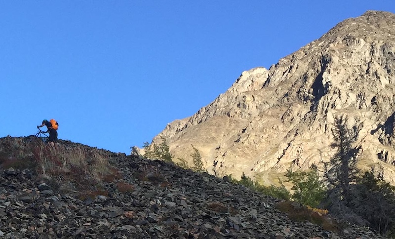
There are other shorter rides you can do in Kluane such as the Auriol Trail; a 15km loop with an elevation gain of 367m. You can make the Auriol loop longer by dropping bikes and hiking into the alpine. Park directions are comprehensive as is signage and compared to the Cottonwood the Auriol is a pleasant ramble although one that is heavily frequented by grizzlies. Keep the noise level and alertness high! The views into the Ruby Range are astoundingly good bang for the buck and most of the loop is totally rideable. The singletrack descent in particular is of high quality
![photo]() The Auriol Trail, a nice loop. Make sure to ride it counterclockwise to maximize enjoyment. Backside of the Auriol Loop some sections of the trail may be washed out but it’s passable. Keep in mind that wow-lying brush is where Mr and Mrs Grizz hang out
The Auriol Trail, a nice loop. Make sure to ride it counterclockwise to maximize enjoyment. Backside of the Auriol Loop some sections of the trail may be washed out but it’s passable. Keep in mind that wow-lying brush is where Mr and Mrs Grizz hang out
![photo]() Descending is fun and fast. 5.7km on singletrack then 2.0km on a mix of double and singletrack on a 8 – 12% grade —- perfect
Descending is fun and fast. 5.7km on singletrack then 2.0km on a mix of double and singletrack on a 8 – 12% grade —- perfect
![photo]() Backside you can see the Auriol and Ruby Range
Backside you can see the Auriol and Ruby Range
________________________________________________________________________________
Alsek trail
The Alsek Trail is a way to explore a small section of Kluane National and is not a singletrack trail. Instead expect a flat 29km trail (one way) that’s a mix of road; doubletrack and small portions of singletrack. The first 15km is a double track you can drive, but it’s very slow due to the washouts crossing the road. You’re probably faster on a bike along that portion. We only rode ~7km to Serpentine Creek before turnaround as the glacial adiabatic headwinds didn’t inspire is to travel further.
If you have the time it would be a very scenic ride to the end as you would see the Alsek, Dezadeash and Kaskawulsh Rivers converge as per the Kluane National description.
![photo]() Nice part of the Double Track.
Nice part of the Double Track.
![photo]() Serpentine Creek Washout.
Serpentine Creek Washout.
![photo]() Ride in the Alsek Valley. Long flat, VERY windy and quite scenic
Ride in the Alsek Valley. Long flat, VERY windy and quite scenic
________________________________________________________________________________
Flight over the Kluane Icefields
The best way to get an idea of the size of this park is to take a Flight Seeing tour, which we did in 2013 overflying the Kluane Icefield. This icefield is even larger then the National Park and extends west into Alaska and south into BC; it’s roughly the size of Switzerland and has a population of ZERO.
Midway through our 2013 trip we passed through Kluane National Park. The park is the location of the Kluane Icefields, a geographical feature straddling the US/Canada border encompassing the Kluane, Chugach, Wrangell, St Elias, Glacier Bay parks and ranges. This UNESCO scheduled site is glaciated permanently snow-covered terrain half the size of Switzerland (approx 21,000 sq kms in area) and is the largest non-polar ice-field in the world. Its population is zero.
The weather was good. One can’t pass up a chance like this. We took a 90 minute flight over the icefields courtesy of Kluane Glacier Air tours (their rather simple website is here). At $300 per person it isn’t cheap but it’s one of those things that we’d have regretted till the ends of our lives for not doing. The entire writeup with more pictures is here
_______________________________________________________________________________
![For a story about biking in Kluane National Park]() The classic Kaskawulsh Glacier from Observation Mountain shot
The classic Kaskawulsh Glacier from Observation Mountain shot
![For a story about biking in Kluane National Park]() Now the views are getting even more mindblowing as we crest the Kluane Icefield and the smooth glacier breaks and ripples. Mt Vancouver is in the marine clouds to the S
Now the views are getting even more mindblowing as we crest the Kluane Icefield and the smooth glacier breaks and ripples. Mt Vancouver is in the marine clouds to the S
________________________________________________________________________________
Where to stay
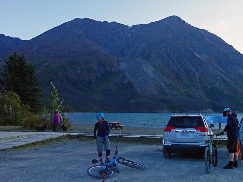
You can day-trip to Kluane from Whitehorse as it’s a 2 hour drive. On the day we did the Cottonwood Trail we started after a good rest at the Coast High Country Inn in Whitehorse which conveniently has an adjoining restaurant and is superbly comfortable
________________________________________________________________________________
![Cottonwood Loop Auriol and Alsek trails]() Comfort of the Coast High Country Inn
Comfort of the Coast High Country Inn
________________________________________________________________________________
It’s also possible to stay in Haines Junction or at least somewhere close. We booked a room at Aurora House on Pine Lake just 10 minutes from Haines Junction
![Cottonwood Loop Auriol and Alsek trails]() Aurora House on Pine Lake near Haines Junction. Very nice and quiet. We just booked one room, not the whole house as indicated by this listing.
Aurora House on Pine Lake near Haines Junction. Very nice and quiet. We just booked one room, not the whole house as indicated by this listing.
________________________________________________________________________________
Trailforks Ridelog of the Cottonwood
Kluane National Park in southwest Yukon is vast being 22,013 Sq km in size and hosting Mt. Logan; Canada’s highest peak at 6050m. The park is so big that you can’t see anything even as high as Mt. Logan from the closest town (Haines Junction) or the roads and/or popular trails in the area. The National Park doesn’t even extend into the Kluane and St. Elias Icefields which extend west into Alaska and south to British Columbia.
To give an idea of scale you can fit the entire country of Switzerland into the National Park and the contiguous icefields. The permanent population of Kluane National Park and the icefields is ZERO.
Perhaps the lack of population pressure explains why Kluane National Park is relatively friendly to mountain-biking (despite lip service Parks Canada is less then progressive when allowing mtb access to trails). Another reason may be that the Park’s Superintendant is knowledgeable about mtbs (he was a past-president of the Whitehorse Contagious Mountain Bike Club). Regardless of reasons, a surprising proportion of Kluane’s trails are OK’ed for biking. We sampled three of them; the Cottonwood loop, the Auriol and the Alsek trails
________________________________________________________________________________
The Cottonwood Loop
It shouldn’t be surprising that one of the mountain bike rides you can do in Kluane is big, long, and committing. The Cottonwood loop circumnavigates the Dalton range which in itself are just foothills and mere pimples on the face of the Kluane Icefields and St Elias Range.
At 85km the Cottonwood loop is more then just a pleasant ramble in the backwoods. It quickly gains the alpine and stays there for a long time being a mix of double track (where you can cover ground quickly), some single track and the last 7km/2 hours a hike-a-bike on a trail beside Kathleen Lake. This ride has amazing views so is best done on a clear day, or as recommended in the Travel Yukon page as a multiday hike or ski. We don’t remember how many creeks we crossed; whether it’s one or one hundred, your feet will be wet. If the first creek is difficult to cross, turn back! That first creek crossing is relatively easy so it will be a harbinger of what is to come. Don’t be that person who took 23 hours car to car and who got washed and tomahawked downstream when attempting to cross a very flooded Victoria Creek. The best time to do this trail is when the creeks are running low. This will likely mean a later-in-the season start around late August to mid September. Bring lots of food, keep moving and you should get out before dark!
Check with Parks Canada before you go. This is grizzly bear central and it's good to know where in particular you will want to have your heads up. Also Parks does conduct brushing expeditions (as does the CMBC) but it's also good to know if the trail is bushy so you can plan accordingly.
We started our day’s trip by leaving Whitehorse then driving 2hours to Kluane, parking at Mush Lake Rd trailhead. We arranged to have our car brought to the Kathleen Lake trailhead at the end of the day by another group who was doing the Cottonwood the next day. You could ride ~10km on the road if you really want to to complete the loop or if you’re into gratuitious pain. You can also arrange a boat pick up at Kathleen Lake to miss the joy of a two hour hike-a-bike which completes the ride (Boreale Explorers may be able to arrange this for you but you will need a sat phone beforehand to communicate with the boat).
________________________________________________________________________________


________________________________________________________________________________
For the remainder of the trip description reference the Kluane National Parks description which is referenced in this article (the wording can disappear from their website so is reproduced)
- The first section (16 km) of the Cottonwood Trail follows the Mush Lake Road, a 22 km one lane, four-wheel drive road joining the Haines highway to Mush Lake.
- Km 0 – 5.5: The trail is flat and easy to follow.
- Km 5.5 – 7.5: At the first trail junction, take the left trail (headed west) as the right trail (veering north) leads to Shorty Creek. From this junction for about a kilometer, you will cross the many channels of Alder Creek.
- Km 7.5 – 12.0: After Alder Creek the trail stays high and dry, crossing numerous small hills and low sections along the north side of the valley.
- Km 12.0 – 16.5: A small footbridge hidden on the north side of the road conveniently bridges the unnamed creek. There are bear claw marks on the trees around here, this area and the old primitive campsite at Dalton Creek are not recommended for camping due to bear activity. Dalton Creek can be crossed via the footbridge on the north side of the road.
- Km 16.5 – 21.5: The road branches, the left trail continues west climbing steadily for 5 km to Mush Lake. Take the right branch turning uphill and to the north. The Cottonwood Trail climbs steadily for the next 5 km, travelling through a spruce forest alongside Dalton Creek. The trail emerges at a meadow; this is the old Dalton Camp that is not recommended for camping. There is an abundance of bear sign in the area; it is obviously a popular travel route for wildlife. If it is near the end of the day and you are in search of a place to camp, your best alternative to continuing on, is to head west following the meadows and find a camp site that you are comfortable with, there seems to be less bear signage in this direction, as it appears to be less of a travel route. If you are continuing on the trail, head right (north) at the primitive Dalton Camp, the trail climbs to a beautiful alpine pass.
- Km 21.5 – 26.7: The alpine pass is known as Dalton Pass. The trail traces the west side of Dalton Creek, crossing many smaller creeks along the way. In spring this area is very wet and not suitable for camping. Grizzly bear, moose and ptarmigan are common to the area, however other wildlife sightings may include fox, coyote, wolves, wolverines, sheep, goats, marmots, pikas, ground squirrels, golden eagles, and smaller birds.


________________________________________________________________________________
Cottonwood loop description continues …
- Km 26.7 – 33.0: From the pass the trail continues downhill, roughly following Shrikes Creek. After a steep switchback, the trail crosses upper Victoria Creek. Posts on either side of Victoria Creek mark the best crossing areas (Victoria Creek is crossed a second time, where it empties into Louise Lake at km 67).
- Km 33.0 – 35.7: The trail heads west (upstream) along Victoria Creek, and is easy to follow up to km 35.7. Although the road continues, follow the trail that cuts up to the right. This is the only way out of the valley!
- Km 37.5 – 39.3: You will gain 150 M (500′) in elevation along this section of the trail as you cross the second mountain pass of your hike. Posts or stone markers mark the trail. If you have any extra time, this is a nice area to explore further.
________________________________________________________________________________


________________________________________________________________________________
Cottonwood loop description continues …
- Km 39.3 – 41.8: You are now in the Cottonwood Valley. The trail winds downhill into groves of balsam poplar trees and wildflower meadows.
- Km 41.8 – 46.6: This is the halfway point of the trail. Cross the smaller creek that joins Cottonwood Creek, however it is best to remain on the left side of Cottonwood Creek, particularly during high water. Watch for a marker downstream that indicates where the trail crosses the creek and follows a series of meadow thickets. It will continue through these meadows until it emerges once again at Cottonwood Creek (km 46.6). When the creek is low, you may be able to walk down the creek bed. It is recommended to obtain water before reaching the designated campsite, as the meadows are dry and water may not be available. Kilometre 47 is the beginning of a 36 km stretch of the trail where camping in designated campsites is mandatory.
- Km 46.6 – 49.0: The trail now turns north and wanders through a spruce and willow forest for about l km before opening up in a very large meadow. The first designated camping area is located in this two-kilometre stretch of meadow (km 47 – km 49). The next camping area is also a designated site and is 18-20 km away at Lower Victoria Creek. There is no camping allowed between these two areas. You may notice a long “bear stomp” that approaches and leaves one of the last spruce trees leading into the meadow. A bear stomp is an area of indented footprints made by a bear (or several bears) following in the same tracks over time. Stomps often lead to scratching trees, where the bears rub and claw.
________________________________________________________________________________


________________________________________________________________________________
Cottonwood loop description continues …
- Km 49.0 – 52.4: The 49.0 km signpost stands out in the meadow. There is no camping from this point (km 49) until Victoria Creek at km 67. The trail leaves the meadow and turns right along the side hill to avoid wet areas. The section leaving the meadow may be spongy and wet however conditions dry up as the trail climbs to the abandoned mining road leading to Kathleen Lake. During mid to late summer Sheperdia canadensis (Soapberry or Buffalo berry) is abundant from this section of trail through to Kathleen Lake. Be vigilant in making noise and very bear aware.
- Km 52.4 – 55.7: The trail crosses a creek and the road continues down through an old spruce forest until you arrive at the Johobo mine site.
- Km 55.7 – 57.3: Look for the remains of the abandoned Johobo mine. The mine operated until the early 60′s. Bornite, a purplish coloured copper ore found in small veins in volcanic rocks, was excavated in the mine. The small mountain on the right contains the entrance to the mineshaft. The cleared area offers great opportunity to see wildlife tracks.
________________________________________________________________________________


________________________________________________________________________________
Cottonwood loop description continues …
- Km 57.3 – 67.1: The next l0 km follows a side hill that overlooks Louise Lake, eventually arriving at the lakeshore and lower Victoria Creek alluvial fan.
- Km 67.1 – 71.3: Kilometre 67 marks the location of the second designated campsite. For the second time on the trip you’ll cross Victoria Creek, however exercise caution as the volume is greater and the flow swifter. It may be wise to spend the night and cross early in the morning when water levels are lower. Search up and downstream for a spot where the stream is wide and shallow. There are signposts on either side of the creek that lead back to the trail.
- Km 71.3 -74.2: There is one additional designated campsite approximately 4 km east of Victoria Creek. This site is located along the shore of Kathleen Lake where the trail crosses an unnamed creek at approximately km 71.3. Pick the site with the best visibility next to the lakeshore rather than in the treed area near the trail. This is the last designated camping site before the Kathleen Lake trailhead. Plan to hike the remainder of the trail in one day (about 12 km). The trail continues along the lakeshore and meets a peninsula at km 74.2. A rockslide occurred at km 72. It is highly recommended to carefully skirt around the slide.
________________________________________________________________________________


________________________________________________________________________________
Cottonwood loop description continues …
- Km 74.2-77.9: Goat Creek campsite has been permanently closed due to frequent bear activity in the area. The trail crosses Goat Creek, a creek that is usually narrow and swift so you may need to scope a good crossing spot. The trail climbs onto and over a rock glacier just past Goat Creek, this section is single track with several switchbacks, rock Cairns mark the way.
- Km 77.9 – 81.0: The trail skirts the slope above Kathleen Lake, crossing a few avalanche paths before descending to the King’s Throne trail junction (marked with a post). The trail veering right climbs the Kings Throne, do not take this trail but continue straight along Kathleen Lake.
- Km 81.0 – 82.7: The trail winds along Kathleen Lake eventually opening up on an old mining road and ends at the Kathleen Lake Day Use Area, 27 km (17 mi) south of Haines Junction.
________________________________________________________________________________


________________________________________________________________________________
Auriol Trail
There are other shorter rides you can do in Kluane such as the Auriol Trail; a 15km loop with an elevation gain of 367m. You can make the Auriol loop longer by dropping bikes and hiking into the alpine. Park directions are comprehensive as is signage and compared to the Cottonwood the Auriol is a pleasant ramble although one that is heavily frequented by grizzlies. Keep the noise level and alertness high! The views into the Ruby Range are astoundingly good bang for the buck and most of the loop is totally rideable. The singletrack descent in particular is of high quality


________________________________________________________________________________
Alsek trail
The Alsek Trail is a way to explore a small section of Kluane National and is not a singletrack trail. Instead expect a flat 29km trail (one way) that’s a mix of road; doubletrack and small portions of singletrack. The first 15km is a double track you can drive, but it’s very slow due to the washouts crossing the road. You’re probably faster on a bike along that portion. We only rode ~7km to Serpentine Creek before turnaround as the glacial adiabatic headwinds didn’t inspire is to travel further.
If you have the time it would be a very scenic ride to the end as you would see the Alsek, Dezadeash and Kaskawulsh Rivers converge as per the Kluane National description.


________________________________________________________________________________
Flight over the Kluane Icefields
The best way to get an idea of the size of this park is to take a Flight Seeing tour, which we did in 2013 overflying the Kluane Icefield. This icefield is even larger then the National Park and extends west into Alaska and south into BC; it’s roughly the size of Switzerland and has a population of ZERO.
Midway through our 2013 trip we passed through Kluane National Park. The park is the location of the Kluane Icefields, a geographical feature straddling the US/Canada border encompassing the Kluane, Chugach, Wrangell, St Elias, Glacier Bay parks and ranges. This UNESCO scheduled site is glaciated permanently snow-covered terrain half the size of Switzerland (approx 21,000 sq kms in area) and is the largest non-polar ice-field in the world. Its population is zero.
The weather was good. One can’t pass up a chance like this. We took a 90 minute flight over the icefields courtesy of Kluane Glacier Air tours (their rather simple website is here). At $300 per person it isn’t cheap but it’s one of those things that we’d have regretted till the ends of our lives for not doing. The entire writeup with more pictures is here
_______________________________________________________________________________

________________________________________________________________________________
Where to stay
You can day-trip to Kluane from Whitehorse as it’s a 2 hour drive. On the day we did the Cottonwood Trail we started after a good rest at the Coast High Country Inn in Whitehorse which conveniently has an adjoining restaurant and is superbly comfortable
________________________________________________________________________________

________________________________________________________________________________
It’s also possible to stay in Haines Junction or at least somewhere close. We booked a room at Aurora House on Pine Lake just 10 minutes from Haines Junction

________________________________________________________________________________
Trailforks Ridelog of the Cottonwood
Author Info:
Must Read This Week
Sign Up for the Pinkbike Newsletter - All the Biggest, Most Interesting Stories in your Inbox
PB Newsletter Signup
0 Comments
Login or Sign Up