Review: 3 of the Best Entry Level GPS Cycling Computers for 2021

Mar 29, 2021
by Henry Quinney  


Whether you’re attempting to climb a million feet in a year, have one heck of a long weekend, or riding so much elevation in a day that you need to fuel with enough potatoes to give yourself radiation poisoning, measuring your riding by total ascent seems to be a popular way to go. Whether you pronounce it dayta or dahta, there’s definitely an increasing appetite among mountain bikers for recording rides.

I’m something of a data fiend myself, although I wouldn’t say I’m obsessed with it. I don’t interpret it in the same way as those VO2-hitting, FTP-knowing athletes in the upper echelons of our sport, but I do like to know what’s going on and, without sounding a dab pathetic, I always record my rides, with an emphasis on the total ascent. Like many of us, I both depend upon and decry all kinds of technology. For that, I am something of a walking contradiction. I know social media and apps aren't my cup of tea, but at the same time, I can’t stay away from them. However, the true extent of my technophilic tendencies is betrayed by how much I really do enjoy keeping tabs on my riding and the regularity at which I find myself poring over my accumulative ride time on Strava.

My main concern is that my device be accurate. If you’ve ever gone up for an extra lap just to roll over a certain distance or total elevation gain, then I’m sure you'll understand. I don’t want some arbitrary yardstick - I want it to be able to consistently and accurately compare my riding. I also like to be able to confirm that my heart is beating, and so, yes, I enjoy wearing a heart rate monitor. Speed and power don’t really concern me and aren't metrics I use to measure my rides. In the past, I have ridden with a power meter but I now just embrace the fact that there isn’t much difference between an “incredibly small amount of power” and merely a “very small amount of power” and so I have pushed it beyond my concern.


photo
Yep, I was that guy. The ability to compare all three at once was worth the strange looks though.


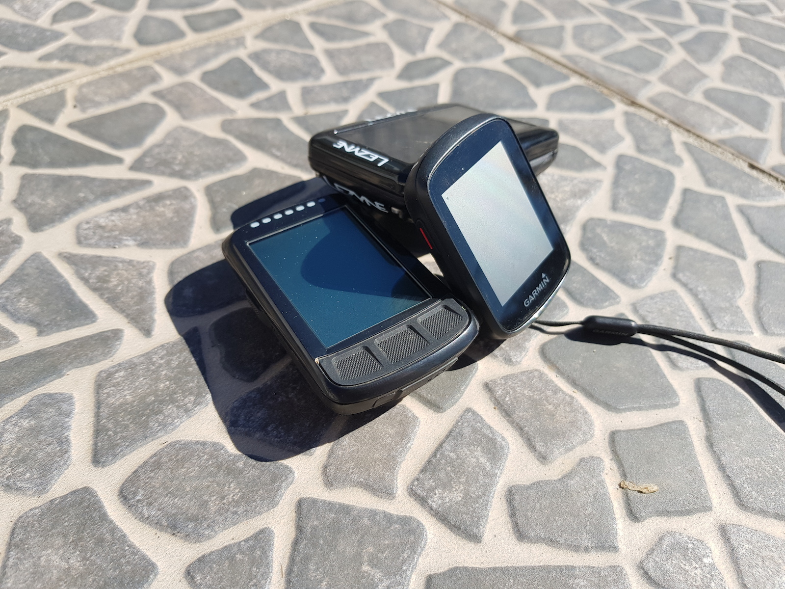
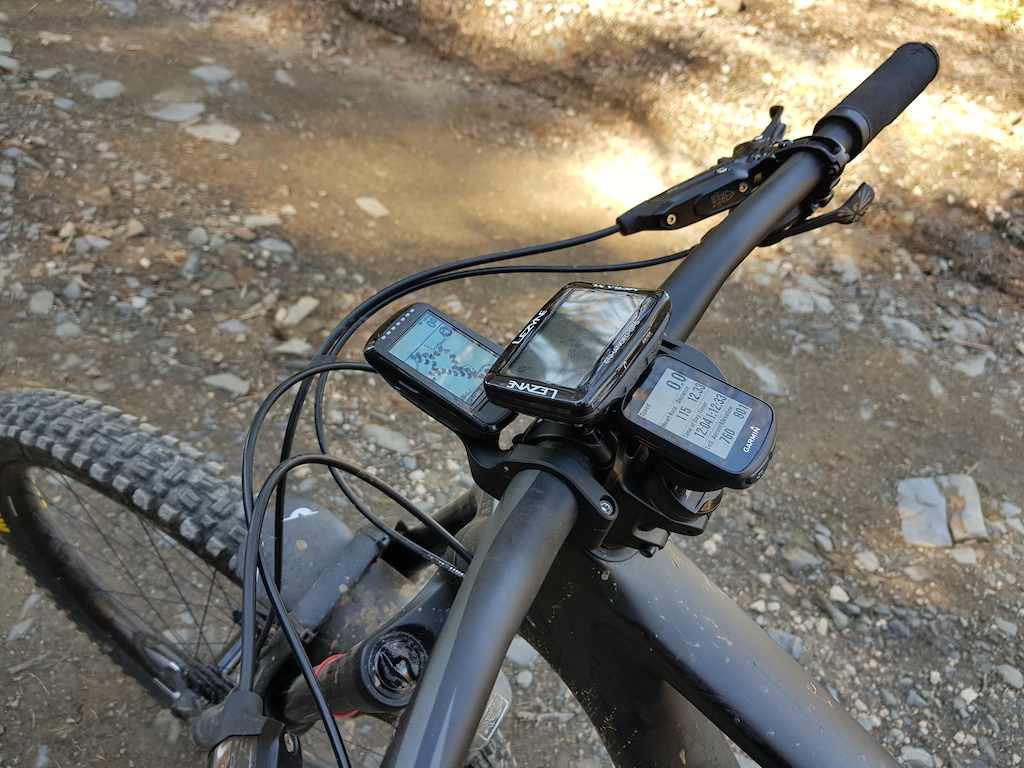
For this group test, I chose to review products that are all around the €200 mark ($240 US). This isn’t a small amount of cash, but in GPS terms it isn’t bouncing off the rev limiter either. The units that fit the bill are the Garmin Edge 130 Plus ($200), the Wahoo Elemnt Bolt ($230) and the Lezyne Mega XL ($200). I tested them over a period of a month and all the riding was done on the same climb. Also, to qualify my statements, when I say things ‘aren’t accurate’ this is related to OS maps and also how they correlate to one another, and whether indeed the information they provide is something of an outlier.

Essentially, I wanted a device to be consistent and easy to use. I have considered navigation, although it isn't of primary importance to me.


Garmin Edge 130 Plus
photo
photo

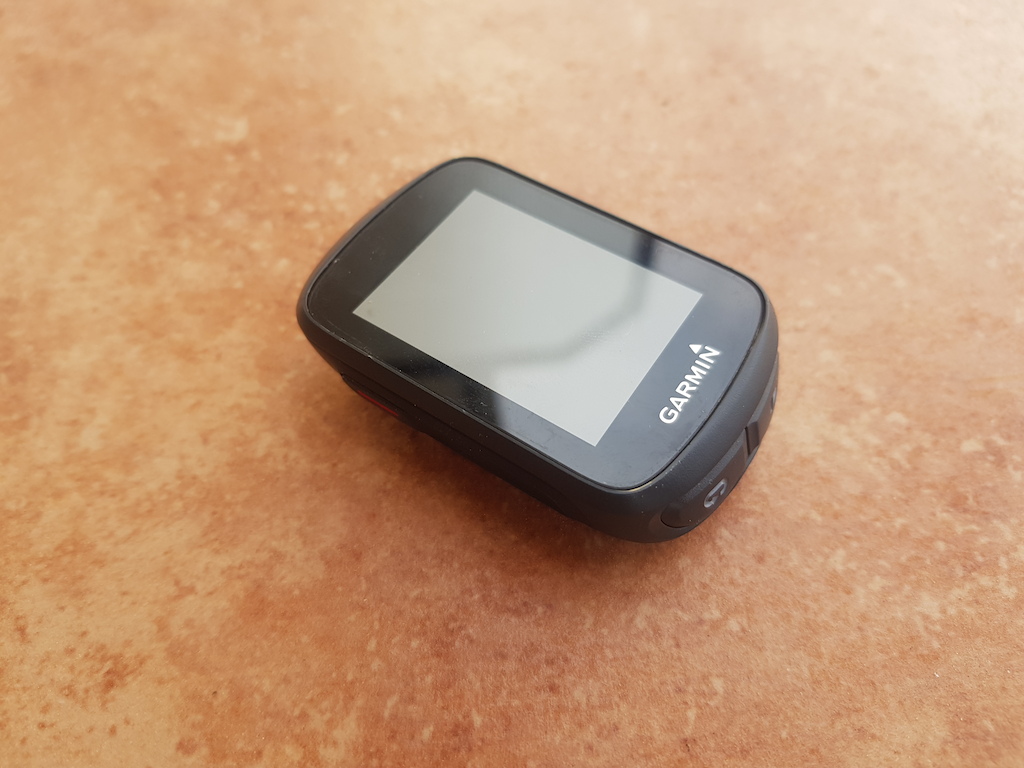
Garmin is now synonymous with GPS for many mountain bikers thanks to the long-time presence and the sheer number of units they offer. From their Edge series of cycling computers to their watches and sat-navs, they’re the only company of the three that I would say is a household name. The unit reviewed, the Edge 130 Plus, sits as a near-entry level piece. It’s similar in price to the Edge 520, but as the newer product, I decided this would be more appropriate to review.
Edge 130 Plus Details
• Weight: 33g
• Screen Size: 1.8” (46mm)
• Price: $200 USD
• Claimed Battery Life: 12 hours
garmin.com

The device is clean looking and almost minimalist. It's small and light and its 1.8” (45.7mm) screen displays well in a mixture of light conditions. Setting it up was relatively easy thanks to the somewhat sleek Garmin Connect App. While the walkthrough process did indeed help set up the device to near completion, it would be nice if data fields could be set via the phone, as opposed to the buttons on the unit itself. The 5 button setup is fine, and if you want to make changes without your phone you will be relying on them soon enough, but it’s not with the same ease as the Wahoo system, where you drag and drop your data fields to the place of your choosing via the app. It’s particularly annoying when you’re hunting through setup pages. It could be the small device, the software itself, or my hamfistedness, but either way it wasn’t as easy as I would have liked.

photo

I opted to run 7 data fields on all these devices. Even though the Edge had the smallest screen on test it displayed the data clearly, even if it wasn’t as quick to jump out at you should you be glancing down at the unit. I appreciate though, that many people wouldn’t run this many fields. The device also used a breadcrumb-trail style of navigation. Using a Strava account to make routes and sync them with your device was remarkably easy. It was perfectly adequate for my purposes but if you require heavily detailed navigation it might be a little lightweight.

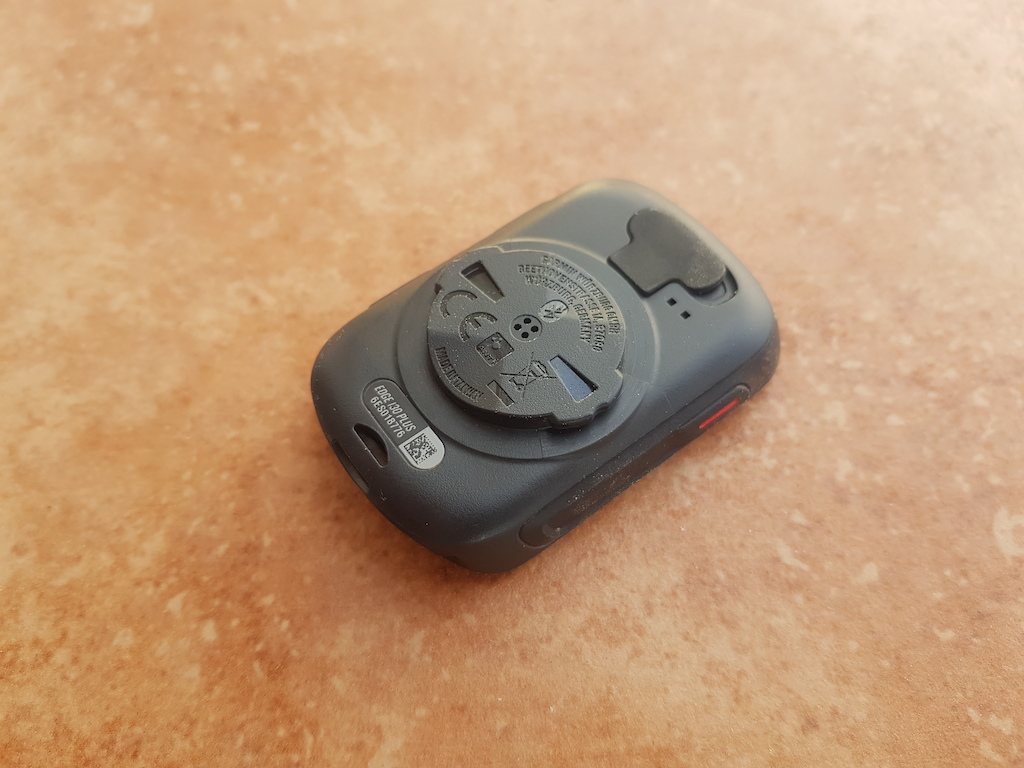
The unit looked clean and, it is worth noting, is the only device to come with a tether. I was sent the ‘mountain bike set’ which included a mount that could be used to place the device behind the bar and over the steerer, although this wouldn’t be included for the $200 model. The problem, in my mind, is that a 40mm stem and high rise bars don’t often play that well with GPS mounts. Of the three, Garmin does have the most aftermarket options though, should the elastic band setup not be adequate for you.

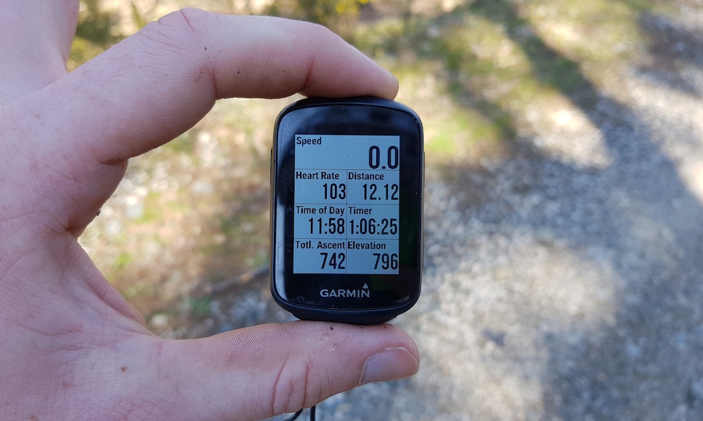
Upon running the GPS for the first time it seemed, in terms of elevation, wildly inaccurate. It’s at that point I realised the default setting was going solely off GPS, as opposed to GPS/Glonass. This second setting proved to be more accurate, although I don’t know why it wasn’t the default.

Even though it was more accurate in this setting, at least in my experience, it did seem to pluck numbers out of thin air. I would always give some time for the GPS to load before riding but it measured my home at an elevation of anywhere between 150m to 350m above sea level, where in actuality it stands at 192m. This might all seem trivial but if you buy a device to measure elevation it’s important. My ride data was probably, on average, 20% out. I know this makes me sound like a bit of an idiot, but all those aforementioned climbing challenges demand some parity between devices. If you found yourself doing 20% extra on an Everest then you'd probably find yourself caring too.

There were some rides where on the usual climb, the device would not be adding any height whatsoever, and on one occasion the current elevation was decreasing as I was going up what I was almost certain was a climb. I mean, I was in the 50T, my feet were stamping on the pedals and it felt like my legs were flailing like Micheal Flatley on a sugar high but maybe I was mistaken.... Sarcasm aside, the unit really disappointed me in this regard. I think it was more of a source of frustration than gratification on most rides. I don’t really want much of a GPS, I just want consistency, which brings me on to my next point.

The Edge 130 Plus is packed with features. I think Garmin have been very ambitious. There’s Climbpro, auto-lap, drink reminders, food reminders, grit scores, jump scores and incident detection. For me, this was just too much and I turned them all off. The jump feature was a particular frustration as it would just never be quiet. If I turned off the noise alerts, I lost the sound for my messages too. On my days off I tend to ride with my phone on aeroplane mode, but when I'm nipping out for a lunchtime lap I like to be able to be contactable. With the 130 Plus it does have the sensible feature of disabling the incident detection for off-road riding though, to save any false readings.

One of the elements of the unit I really liked was how it connected to your phone. You wouldn't have to boot up the Garmin Connect app for it to offer seamless uploads and text notifications. This was the only device on test to do this, the other devices required you to start up the app to establish a connection between the phone and device. The Garmin can also make benefit from custom fields through the Connect IQ extension. This will really be to some people's liking. Its 12 hour claimed battery life also checked out.

I think, and it may sound a little bit self-satisfied, but we’re in a world where any piece of technology becomes as much about validating its user as it does about its original purpose. Phones, for instance, are more about dopamine hits than ringing mother dearest. The drawback of having a mobile is fast becoming that you’re at risk of somebody ringing you on the bloody thing. I’m kind of loathed that the device seems to willingly go into this. Personally, I want a training tool and not a training partner. The jumping feature feels more "Napoleon Dynamite" than it does "Red Bull Rampage". To test the feature, I did a bunny hop rolling down a fire road. It congratulated me on doing a 4.5 meter jump. If anyone has seen my bow-legged bunny hops in full flight they’ll understand that this is a gross exaggeration and, without getting slightly facetious, I wonder what this will mean for the slightly over-confident beginner, the local double and a somewhat irresistible pull towards appearing in Friday Fails. Eventually, I could take no more and I turned off the noise-alert for good, if only so the beeping would abate. I don't need to be told that a computer thinks I've done a "great jump!".

It’s a nice device, it looks tidy and is very small and lightweight. I’m sure it will offer a lot to a lot of people. However, my only regret is that I should have included the older, and now price-reduced, Edge 520. It’s a far superior device, in my opinion. I imagine that over the next few years Garmin will refine and enhance their features to become something like industry standards, I just feel that it all asks too much for something that struggles to do the basics correctly. If you don’t care about elevation but do enjoy a feature-laden device then this isn’t a bad option, but I would struggle to call it the best.


Pros

+ Lots of features
+ Minimalist and low weight
+ Automatic phone connectivity

Cons

- Lots of features
- Accuracy


Wahoo Elemnt Bolt
photo
photo

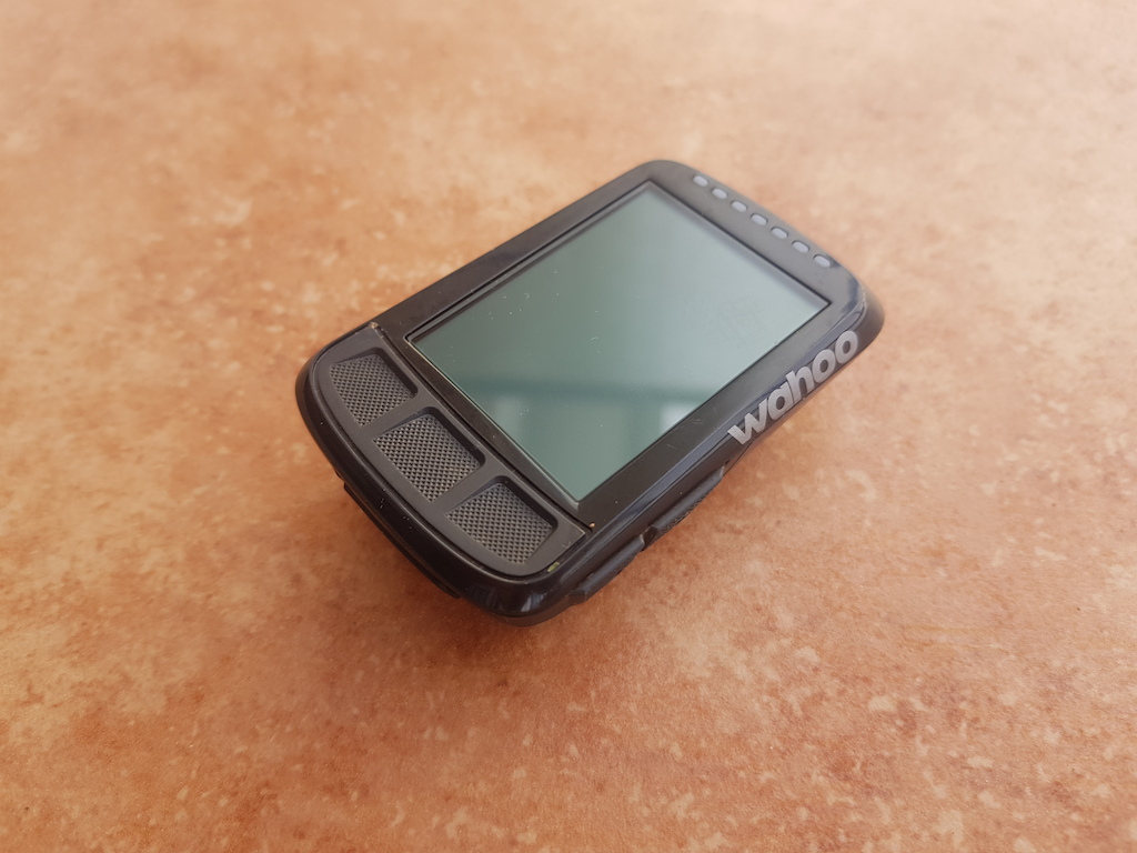
Wahoo is a company that’s quickly progressed from cheeky little upstart to industry titan. It specializes in all things training and its product line, which originally started off as Ant+ accessories, now consists of Smart Training devices, watches and also GPS Units. The device we tested was the Wahoo Elemnt Bolt.
Elemnt Bolt Details
• Weight: 62g
• Screen Size: 2.2" (56mm)
• Price: $230 USD
• Claimed Battery Life: 15 hours
wahoofitness.com

Firstly, setting up this device was by far the easiest. Wahoo have done a great job at making their app a genuinely easy experience. It’s intuitive, gratifyingly concise and, as a friend of mine put it, “Garmin or Wahoo is like Android or iPhone” and it kind of gets it in one. The data fields can be changed on the fly and everything is where you would expect it to be. Once using the device, you can also use the two side buttons to zoom in and out your chosen data page to increase or reduce the number of data fields. This is a good feature but, to be truthful, the app did such a good job of setting up the device I initially hardly realised that there were side buttons at all. There is also the option of scrolling separate data pages.

The unit comes with an "out front" mount in the box. This is a nice touch for XC or road riders but for mountain bikers, it’s not particularly useful and, if anything, highlights one of my gripes with the device. On the front edge of the device, it’s shaped so it cradles the mount to allow air to "slip past". I don’t know how fast you have to go to reap this benefit but, I’ve got to tell you, I don’t think I'm in danger of getting there.

photo

The problem is, due to this cuff you can’t run the mount backwards and have it over your steerer. It’s also annoying that they do sell a tether but it’s not included in the box. I would rather have a small and useful tether, rather than a large mount that can only be used on a road bike. Not only does it look, to me at least, kind of absurd to have a device sticking out the front of your bike much like an underbite on a jack russell, but I also have concerns that having a device there is asking for trouble in terms of impact. There is a small bolt offered the secure the device to the mount but for the aforementioned reasons, I didn’t feel this was useful if even relevant to the needs of mountain bikers. That all being said, the second and more typical mount included is secured by cable ties. It works well and seems very secure.

Unlike the Garmin, the app doesn’t seem to work in the background and to enable auto-upload and text notifications you will need to have it running. It’s not the end of the world but it would be an added bonus.

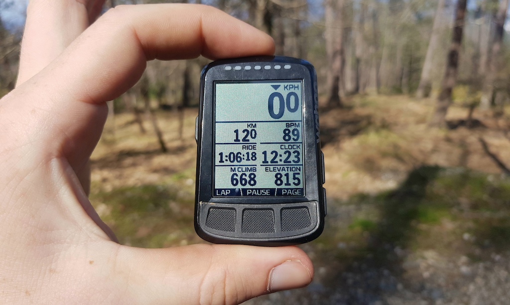
The device seems to navigate well. While it doesn’t benefit from the large screen of the Lezyne, the way the Elemnt uses the 2.2" (56mm) screen is quite efficient to give turn by turn directions. It comes with road maps already loaded and has ample room area to convey the information. Yet again, it’s the sheer functionality of the software and integration with the app that makes the Wahoo so enjoyable to use. Loading a route was so easy and done with minimal fuss. The middle-of-the-road 15 hour claimed battery life proved to be justified, too.

As for using the unit itself, I think it was the strongest on review. The data was always very accurate and never left me second-guessing. I even went high into the mountains in a heavy downpour when it was particularly cloudy and it never skipped a beat. This is normally a condition that GPSs that use barometers struggle with but the Wahoo held its nerve.

Another really nice feature of the Wahoo is the end of ride summary. It will tell you running weekly totals and I found it to be quite useful. To be honest, I have little interested in the projected fatigue that a unit might throw out after seeing a mere snapshot of your life, but running totals are useful as it helps me make up my own mind.


Pros

+ Best companion phone app
+ Very easy to use
+ Most accurate on test

Cons

- No tether included
- Its shape doesn't give as many mounting options


Lezyne Mega XL
photo
photo

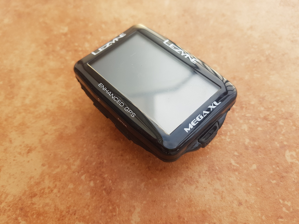
Lezyne is a company that seemingly makes every bicycle accessory you could imagine. Tools, lights, pumps and, as of a few years ago, GPS units. But how does this unit stack up to the two big players of Garmin and Wahoo? To glance at the tech sheet, one thing that stands out is the long 48 hour claimed battery life. It didn't quite make 48, which might have been may well have been my settings, but it was close.
Mega XL Details
• Weight: 83g
• Screen Size: 2.7" (68.6mm)
• Price: $200 USD
• Claimed Battery Life: 48 hours
lezyne.com

Unsurprisingly, the Lezyne Mega XL is by far the biggest unit on test. This is something that is going to be down to the individual but I really liked the size of it. It also has the distinction of being able to run in landscape or portrait mode. It was one of those lightbulb moments and I thought "Why doesn’t everyone do this?". It’s a vastly superior orientation in my mind. I think it allows for a high number of data fields, again 7, to be shown particularly efficiently. I think it also lends itself to the needs of mountain biking very well. I wonder if we tend to see less landscape GPS displays due to the adverse aerodynamics it would offer a road cyclist.

The device was relatively easy to set up although its app is probably the least sophisticated of the three. The app feels far removed from the iPhone or Android debate and feels more like Windows 95. It works, and you can change data fields using your phone. Like the Wahoo though, it requires the app to be booted up to send your phone notifications and uploads. Also, even though I selected the Auto Upload setting, and double-checked numerous times, the device would only upload the rides by manual selection.

The device seemed accurate, except for one ride where it went completely off the rails. It only did this once though and didn’t seem to make a habit of it. When I turn on the device it tends to over-estimate my elevation by consistently 40m. This then seems to level out as I commute to the trails. This isn’t a problem for me as I have a relatively flat 3km commute to the trailhead but for those that do climb straight out the door, this might be irritating.

photo

The Lezyne is a big unit, with a screen size of 2.7" (68.6mm), and is the heaviest of the three at 83g. Mounting it wasn’t all that easy. As I mentioned earlier, a short stem and bar didn’t really mate that well with GPS units. I eventually went for a slightly adventurous mounting over my stem. That ride, coming through a particularly fast and rough section the unit was jettisoned off the side of the trail due to a band snapping. Was this the unit's fault? Well, of course not, but it did highlight the use of a tether and this unit's incompatibility with one. It’s a really big drawback for a device, in my opinion. It’s not that I don’t think it’s secure to the mount but rather it ensures that even if the mount works loose your unit won’t go anywhere.

I managed to find the device in the undergrowth by using the signal strength indication in the app to triangulate its location. It wasn’t a big deal but it was a half an hour faff that could have been avoided. The placement I eventually settled on was using some cable ties to overlap the mount. It was a little fiddly to set up but it’s at least secure.

The Lezyne, with its large screen and full mapping, work well with one another to aid navigation. Yet again, the app seemed to be the largest obstacle and it required a thorough googling. You have to download a route from your PC to then upload it to your Lezyne Roots account, which will subsequently sync with the GPS. Easy, once you know how. Then, once it’s on the app you click start on the phone app to start the route, and it will work on the unit. This was all somewhat bewildering and made me feel a bit of a neanderthal but I got there in the end. For comparison, the Wahoo took me around 15 seconds.

It also doesn’t come with maps pre-downloaded. You actually take a screenshot of the area that you would like to use in the app and then it syncs. Yet again, it didn’t strike me as particularly intuitive.

I never quite clicked with the four-button operation and I always found myself second-guessing what I actually wanted to do. This would probably lessen, should I spend more time on the device, but it was the least intuitive of the three to use. Also, rather curiously, the time of the day display seemed to have a will of its own and I tended not to trust it. When paired to the phone it worked well but on one occasion, when left to its own devices, it just decided that it was going to run 20 minutes out.

I actually quite like the Lezyne and it’s a device that I would not be disappointed with if I were to use it long-term. It offers excellent battery life, seems robust, well made and the sheer size of it lends to being very good at relaying data. For me, the biggest hurdle was the app and the buttons. I never quite found it to be anywhere near intuitive, even though I gave each device a week of solid use whilst riding every day. That said, if you demand something that is reasonable, if not irrefutably accurate, you can navigate the app and get used to the button operation, this could be a very good device indeed.


Pros

+ Can be used in landscape mode
+ Long battery life
+ Seems particuarly robust

Cons

- The app isn't great
- Buttons will take some learning
- Time of the day isn't always accurate
- Device can't be tethered


Pinkbike's Take

bigquotesI think each of the devices offers something, it really does just depend on what you're after. For instance, if elevation-accuracy isn't your thing then maybe the Garmin would be a good option. Similarly, if battery life is paramount then maybe the Lezyne. With all that said, I think the most rounded GPS on test, and my personal favourite, was the Wahoo, both for its accuracy and ease of use. Henry Quinney


Author Info:
henryquinney avatar

Member since Jun 3, 2014
324 articles

135 Comments
  • 27 4
 Why would I want to get one of these vs tracking my ride via smartphone? Not trying to be snarky but genuinely curious.
  • 46 5
 Smartphone GPS is pretty poor compared to a dedicated unit
  • 10 37
flag Losvar (Mar 29, 2021 at 1:31) (Below Threshold)
 @boozed: Not really though.
My phone is just as accurate as the gps in my car when driving.
  • 113 2
 Being able to look at the device without running the risk of losing your $700 phone.
Tracking all day without running down the battery of your only communication device in case of emergency.
  • 67 1
 @Mac1987: and let's face it, smartphone on the bars is not a good look unless you're delivering pizza...
  • 33 0
 @Losvar: Without dumping a wall of text, I'll just say that riding MTB trails is very different to driving a car on roads.
  • 16 1
 Yeah I have the same question, I use my smartphone to record rides on Strava. I'm not too fussed on glancing at stats, if I'm bothered I will just stop and pull my phone out. I only really use it to track distance, elevation and compare my times to previous times.
  • 13 4
 It’s nice to have a redundant device that isn’t your $1200 iPhone that’s rapidly draining battery for plenty of reasons. However, with a top mount on your bars there’s a pretty low chance you’re breaking the phone or the head unit, so that’s not always a great reason to switch. For riding solo in a new area, the redundancy is pretty useful. For riding solo or in a small group somewhere remote, better add a garmin or similar communicator like backcountry skiers do. For a couple hundred bucks entry point - literally a couple of tires and some brake pads nowadays - you can have a standalone unit that’ll keep you on-track wherever you need it.

Head units will pick up on not just HR sensors, but your other ant+ sensors on the bike, electronics like di2 or AXS, and (speaking for garmin) have preloaded maps that are normally over and above what even good crowdsourced ones like trailforks pro or Strava will offer - not just trails, but old fire roads, service roads, etc. that might be reclaimed by the woods but offer a quick shortcut out if something bad happens or you just need a quick way out (I’ve lost track of how many times it’s getting late and the garmin has a quicker route out of the woods than trailforks does). Longer battery life, while still using gps, glonass, etc. Especially if you have the $, a cheap unit like this is a no-brainer. If you don’t want a head unit, springing for a garmin smart watch with mapping is a great redundant unit if you need it as well - plus, much better for gym/hiking/running or whatever.

They do have plenty of other features like bike alarms, crash alerts, etc that I don’t personally use but I’ve had some riding buddies swear by. And while other people might not care about the training metrics, the estimated vo2 max, training with power, calorie/water burnt, perceived exertion, live segments, and rest of the bevy of integrated training aids all in one place which are far beyond what you’d get with a smartphone.
  • 3 2
 Ultiately it is a matter of need vs want. Most people do not need the accuracy *&claimed* by the higher end units). I used my phone for years and then decided to go with a wearable once ANT+ HR was made available in the smaller, bracelet style devices. I'm not super into stats, just want something to roughly track aggregate distance and elevation more out of curiosity with an eye to heart rate as I'm getting older. The data isn't consistent enough for a pro, I would assume, but it works for me as a yardstick.

My riding partner is a tech geek and he has cycled through every top end garmin released over the 20yrs we've ridden together and they do not seem to be any more consistent than even basic devices and I suspect that is because we primarily ride in forest. There will be a 10% differential sometimes in the forest, and despite his reluctance to see it, both devices vary (it's obvious when you ride the same lops on track on Strava). On the road they're about the same... we did a 200km ride last year in wide open terrain and I rode 100m more to get the same distance, pretty good for 5x less money.

Biggest downside to Garmin seems to be satellite locking... he turns his unit on when he arrives and often it still hasn't locked on to a satellite. And my wearable battery lasts longer.
  • 5 0
 I used only a phone for tracking my rides for years, and it was fine because I was only interested in knowing something about the ride after the fact - distance, climb stats, KOMs?? I very rarely forgot to start Strava and had no reason to get a GPS because I would always have my phone with me for emergencies.

This year I've begun *seriously* racing and the GPS is an absolute game changer. No need to carry a phone for a race, and I can see how long I've been racing (my time) my heart rate (important to manage) my distance (when do I start my kick?) and more. And if you find yourself being a d*** about KOM's, well, you can set up the Garmin to time a specific segment and it will help you beat your PR's or the KOM (for ascents... wouldn't try checking a screen while ripping descents).

I will also say the nav features of a Garmin are very helpful for road / gravel rides. Never really used it on a trail system on mtb, but great for learning new routes without having to continually take out my phone and check Google Maps.
  • 8 13
flag isawtman (Mar 29, 2021 at 5:49) (Below Threshold)
 Why would you need any of these devices at all. Just stay on the trail and have a map
  • 2 0
 @isawtman: there's a lot more than navigation you get from tracking rides with GPS. Sure, "need" is a strong word, but it's quite nice to track ride distance, especially cumulative ride distance for your bikes, to help with service intervals. Plus, it's pretty rad to know how many miles you've traveled by bicycle over the year, or even over the decade. Sure, I can do that with a map and a paper and pencil, maybe some graph paper and my grandpa's slide rule, but an app like Strava makes it pretty fun. Welcome to the 21'st century bro!
  • 5 1
 @Mac1987: put the phone on “airplane mode” while running the GPS and/or Strava. It’ll use less than 10% battery over the course of a 6-hr ride.
  • 13 1
 (1) Phone uses battery like crazy compared to my Garmin which will last all day. "Then just use the phone in airplane mode to save battery" some might say. I would, but that makes it tough to get a phone call if my phone is in airplane mode so that doesn't work for me.
(2) "Well, I ride in the wilderness so there's no cell reception anyhow" me too, but I can still get a call or a text when I happen to be in the satellite footprint every now and then and that's important to me.
(3) I definitely do not want to put my multi-hundred $$ phone on a mount on my handlebars because it may get damaged in a fall or get mud/water splashed on it.
(4) "I use an old phone just for tracking my rides" Then you've just spent a lot of money on a complex device when you could've saved $$ on a simple bike computer.
(5) "I got my spare/bike phone for $5 at a garage sale" Okay - you win.
  • 1 2
 Because then you have to mount your phone to the handlebars?
  • 3 0
 If you just want to save your data and view it afterwards, a phone is more than enough. But if you want to view your data while riding, a GPS unit is much better. For example I have a tendency to ride too hard and run out of steam, so being able to see my heart rate while riding and keep it on a reasonable level is helpful. I don't buy the accuracy argument, I think the phone GPS is good enough. But I don't want to mount my expensive smartphone on the handlebar when riding trails.
  • 11 0
 @boozed: I assumed this would be true, but it is actually not my experience. About half of my riding friends use a dedicated GPS (myself included) and half use iPhones. With the GPS on the bars and the iPhones in the backpacks, I consistently see better tracks on mountain bike trails from friends' phones.

Likewise when my GPS is actiing up so I run Strava on the phone, and then later compare tracks, the phone's route is always more accurate.

Regardless I continue to use a GPS for a few reasons. First, my cellphone is my safety net, so it usually stays in the middle of my pack, sometimes turned off. No need to be draining the battery if I may need it a few hours later. Second, I like having the computer on the bars. I like knowing what time it is, how far I've gone, and sometimes having a map available.

And finally, I really appreciate having my Garmin tell me that I just got 0.23 seconds of airtime off that last jump. Just kidding, I don't appreciate that at all.
  • 1 0
 @dthomp325: Not if you’re just tracking. If you want to see current speed, location, etc., sure. I do actually like the MTB focused Garmin models, though I’m not sure the extra info is really all that valuable. Cool, yes. Valuable?
  • 1 0
 @dthomp325: or you put the phone in your pocket/pack
  • 3 0
 If you're going out for longer rides having a dedicated gps stops your phone's battery from being drained so quickly. If you get into trouble and your phone is dead cause you've been using strava then your pretty much stuffed.
  • 2 2
 @GordonU: Put it in airplane mode, problem solved.
  • 2 0
 @stevemokan: airplane mode also makes the GPS far less accurate.
  • 1 0
 I used my phone for tracking for years, but starting running into battery life problems on longer rides. It especially didn't like tracking in areas with poor cell coverage. My Wahoo Bolt doesn't care about the cell phone until I get home and start the phone app to download the ride data.

I also use a heartrate monitor which seems to connect to the Wahoo easier. I also use cadence on road rides (rarely on mtn bike rides unless I'm using clipless).
  • 1 0
 @jalopyj: I was tracking my ride on Strava for a year alongside my simple speedometer with barometric altimeter. The smartphones don't have the barometric device. So, you're left at the mercy of the averaging or someone else's elevation recordings. When calibrated on the speedometer and if the weather and temperature doesn't change much, devices with barometric pressure for altimeter is fairly accurate. When I compared the elevation gains from my VDO with the Garmin 830 and Strava, the ones with the altimeter seems to correspond where the Strava recording can fluctuate 100m to 200m at times. I've also seen fluctuations from Garmin devices. However, I know mine is more accurate because I calibrate mine every so often to make sure my elevation is within +/-5m. Some of my friends who have the same device doesn't calibrate theirs at all and when they upload their data, it's off by as much as 200-300m a few times. When temperature varies wildly on a ride, the altimeter may be wrong, unfortunately.

The other thing is, all three of these devices, especially Garmin and the Wahoo devices (not sure about the Lezyne Mega), will have ANT+ wireless device tethering. So, you can attach a speed, cadence, heart, power meter sensor to that device. It's pretty cool. Also, I discovered that the ANT+ wireless signals are unaffected by LED emissions. So, recordings won't be cut off when you ride at night with any handlebar lights turned on. The speed/distance is also more accurate when you have the speed sensor calibrated to the size of your wheel with the tire on. Again, some of my friends don't calibrate this and depend on the Garmin sensor to do the averaging over a long distance or have Strava average out the distance, it can sometimes lead to either shorter or longer than expected results. On Strava, I also noticed that if you're in the trees or tall building in downtown, the GPS signal might now reach your device. So, you may lose a whole lot of distance on recording.
  • 2 1
 I get more KOM's with a phone and I'm old, fat and slow....
  • 4 0
 I like using a GPS unit on my stem so that I can read the numbers, follow the map, etc, while my phone is safely protected in my pack... I ride alone most of the time and I like knowing that my phone isn't going to get broken when I OTB, in case I need to call for help.
  • 1 0
 Main reason I have a GPS vs cell phone or basic bike computer is I’ll do bike trips and after getting lost multiple times in foreign areas you eventually learn it’s nice having GPS instead of wondering the SoCal desert at 3 am after missing a turn in Noble Canyon. Pulling your cell phon out of your bag at every junction is not convenient and mounting it on your bars is asking for trouble. Personally the lezyne Mega C has been good for me.
  • 1 0
 I like having some data on the bars. I have a very cheap Bryton Rider 15 ($70 us) and the time, temp, distance and compass are very handy. I use it as real time data and my Apple Watch I use for strava. On the times when I forget to start strava, I still get ride data.
  • 1 0
 I got mine so my phone wouldnt use its battery when i went to Moab. My old phone used to last 2 hours while using strava
  • 1 0
 @isawtman: Bike Computer/Wearable device etc... The 1. reason is data. Unless you are at the bike park, computers make XC riding a whole lot more enjoyable. Pace yourself against the top riders in the area, set PRs, track top speeds, see avg heart rate, how many calories you burned and so much more. They absolutely have their place.
  • 1 0
 @GordonU: My Motorola phone has a 5000mAh battery ... maybe Strava would use 20% of battery for 2hrs? It's minute and never been close to a problem.
  • 1 0
 @Dmaxwell: to each their own - all of these things make riding less fun for me.

I use data on the road when I have nothing to look at but white line for 100km (roads in my area are straight and boring AF).
  • 12 0
 The Garmin has an atmospheric pressure sensor to determine elevation, you just have to set te proper elevation where you know it is accurate, and then it works! No need for GPS in that case... For the rest, this new model allows to get Galileo signal, which is the european accurate GPS signal, and the location is very precise in that configuration.
  • 1 0
 Indeed, my Garmin Instinct Solar watch is the same way. As long as it's calibrated to a known elevation, and set to Altimeter (not Barometer), it works pretty well!
  • 1 2
 @iduckett: So would you have to know the local altimeter for every different location and time you ride?
Altimeter changes daily even in the same location.
  • 5 0
 @Beasthead741: Not really. You can set the current elevation at the start location as is as a "home" elevation and it should adjust according to that elevation for the ride. But if you know the location's elevation right before the ride, you can adjust it manually. Either way, you should come out with approximately the same elevation at the same location. However, if you have any temperature swings or if the weather changes drastically, it really screws up the elevation gains throughout the ride.
  • 2 0
 @Beasthead741: Yes... the temp swings and weather changes can affect it, it's decreased almost 500ft in some cases without moving (over a day or two). BUT, I'm really more interested in the CHANGE in elevation, for my rides/hikes, etc. And for that short period of time (1-2 hr ride) the Altimeter is accurate (unless it is extreme weather like CSharp said). I take a look before I go adventure, and if it's off by 50-100ft initially, I'm not going to lose any sleep over the min/max elevation. Even if it is, I can always revert to GPS elevation, or Strava elevation.
  • 1 0
 @Beasthead741: I also saw my watch has an Auto Cal setting that calibrates the Altimeter elevation upon starting a GPS activity, so that explains why my elevations have been fairly accurate. So an extreme weather event is the only real concern. I'd be curious to know if the Edge 130 has the same functionality.
  • 10 0
 OK If you use the Aero mount for Roadbikes with the elemnt than it Sticks Out but If you use the mounting Plate for the handelbar it isnt. Bye far the best Bike GPS in my opinion. So easy to use
  • 3 0
 Yeah when i got my Element Bolt a few years back it came with a mount that can be ziptied to the bars (or really anywhere I guess)
  • 8 0
 The inaccuries in elevation measurement is not due to faulty devices, it is a statistical effect high sampling frequency and cumulative errors of measurement. Id you measure height Y with inaccuracy +/- X, it matters how many times you measure T.
You need to lower the sampling frequency, surely you do not need to measure your position every 5 seconds
  • 8 0
 Hello there. Yes, a very good point and this is essentially the premise I worked under. I rode the same single 797m climb (and only this climb) during the whole test period which lasted around six weeks. On that climb, I had several markers where I knew the exact height above sea level, which I confirmed with mapping software. As you said, being accurate in the moment isn't here or there but over the course of a climb some of the devices would be between 10-20% out, and that could be either above or below.
  • 6 0
 Depends if they're barometric altimeter or GPS. GPS is terrible for altitude but good for position.
  • 1 0
 @stevemokan: yes, that is true. On the graphics you can see that some elevation/distance gains are somethime impossible or not possible for the trail.
  • 15 8
 From experience using a Lezyne Mega:
- IMO the use of hard buttons instead of a touchscreen is an absolute plus, but that's half the reason I bought it. It has four buttons; if you can count to four, you can figure out how to use them.
- The app is definitely a bit clunky, but not unusably so. It's just basic. It's easier to set up the device through the app than through its own menus.
- I've never had any trouble with the time being incorrect. It gets its time from GPS so I would be very surprised if it ever was!
- I'm not sure what "device can't be tethered" is supposed to mean. It can auto-upload activities to your favourite tracking website, display live segments and phone notifications, among other things, but I don't use most of those features so maybe I'm missing something.
- Its navigation usability is probably a bit behind the others, but you absolutely can feed it a route that you've created in Trailforks or whatever. The Mega C with its colour screen might be better for this.
- Updating the device's firmware requires plugging it into your PC. It presents to the PC as a USB mass storage device so you can back it up very easily.
- The GPS traces it produces are pretty accurate. I've seen Garmins do far worse.
- The barometric altimeter isn't very accurate, but miles ahead of a wearable.
  • 3 0
 The missus uses the one down from this, the X shaped mounts on the back of the unit keep snapping off, its been back for warranty twice now and this is only on road bike. That said it looks like the mount might be replaceable on the XL, but still, the attachment mechanism isn't the best for strength/security/not sticking up miles.
  • 22 0
 Tethered as in a physical leash to the bike.
  • 1 0
 I'm using Mega XL for at least two years now and never came close to familiarity with use. The button functions are a bit off, the auto-sync function works well only after few latest updates, but it's the long battery life and data accuracy that keep me with it. I've been told Wahoos are the iPhones of GPS units, but I never felt I need to switch to color screen. I believe Lezyne will release a refined device soon, so far, it's still worth the money.
  • 2 0
 @nonhero: Ahh right, sure. I have had mine come off in crashes.

@pbuser2299: The mount is a metal plate now, so they must have had to replace quite a few for that reason.
  • 6 0
 @boozed: Hi Boozed, thanks for the feedback on the Lezyne. As I said, it definitely has a lot to offer.

I can't say I understand why the clock went out of sync, but I can certainly say that it did. It was very weird as I thought the whole premise of triangulation was based on timing. Ha! I assume it must have been some kind of bug.
  • 1 0
 @henryquinney: No worries, I thought it might be worth adding some long-term user observations, although my "testing" certainly hasn't been comparative or methodical. I think it's pretty decent considering what you get for the price and it works well for me, but it certainly has enough oddities that it's easy to understand how it wouldn't work for everyone. If it broke, I would buy another one to replace it.
  • 1 0
 The Lezyne Mega or the smaller version was high on my list after I lost my tiny VDO M4 speedometer. I had lost another VDO computer before that as well when they unclip easily from their mount on any jarring motion from the bike (eg: crash). The only reason why I didn't go for the Lezyne was because it doesn't support a way to tether the device onto the bike. After losing two computers, there's no way I will lose another device, especially when it is over a few hundred dollars! I got the Garmin 830 bundle instead for nearly the same price. I'm pretty happy with it so far, especially when you get lost out in the woods and need the GPS to guide you back to the nearest trail. The tether that came with it saved me from losing my Garmin device several times already. In addition, if I didn't tether the device and it got flung out in the bush, I can try and track it down with my iPhone.
  • 7 0
 I've had an Elemnt Bolt for a couple of years now. Fantastic device. It works great, has all the necessary features and no useless gimmick stuff. Battery life has remained on a good level. I use the out-front mount on my road bike and used the zip tie mount on my MTB. Although this year I bought a Gravity Cap mount for the MTB. It allows you to mount the computer on the headset top cap. Strongly recommended!
  • 4 0
 I had a Garmin 510 for a few years and never liked it. Aside from the things listed, they had less support across things like my bike trainer and the Garmin had all too many failed recordings and corrupted ride files. The heart rate monitor I had with it was pretty flaky as well. I'm on the Wahoo now and have had the complete opposite experience, it really is a well done device.
  • 4 0
 @henryquinney nice work on the review. I decided on the Wahoo based on a friend’s advice. It’s awesome! But I don’t need to run the app to get text messages on the Bolt (I have an iPhone). You can also set it to automatically upload your ride as soon as you hit stop. Thanks!
  • 2 0
 How does that work, I am pretty sure you need the app open on the phone for it to work. I can't get it to work any other way
  • 1 0
 @Nairnster: Nope, you don't need the app open for this to work.
  • 1 0
 Also, his review shows in the cons "Its shape doesn't give as many mounting options" which is odd. You can mount this in a number of ways. I have mine mounted on the stem cap using a k-edge mount.
  • 1 0
 @gerrycreighton: on wahoo page it says you must have the bolt paired to the phone. Mine only pairs when the app is open, so how do you keep it paired with the app shut?
  • 2 0
 @Nairnster: on my android phone (Pixel 3A XL) you need to specifically give the app permission to run in the background, so take a peek at the app's permissions in the phone's app settings or equivalent menu on your phone.

Edit: Just to give my 2 cents, I find the unit works very well and I bought it specifically due to the battery life so I don't have to charge it every night. The black and white screen can be hard to read in low light situations when the backlight is overkill, but the display is easy to read and use otherwise. My only real gripe is that when riding gravel often the dirt roads are not displayed (to declutter the screen) when zoomed out far enough to see where a road goes when riding out in the country. I used it for a race that took 11 hours to complete and finished just after nightfall and had enough battery using GPS guidance the entire time (and some backlight usage in the evening). In the before-fore times (pre-covid) it was available as a bundle with Ant+ HR strap, speed and cadence sensors for $300 which saved a fair bit of money compared to buying separate sensors. I don't think the speed & cadence sensors are very useful for MTB so those live on my gravel bike. There's aftermarket stem and steerer tube mounts that I use for MTB and they work well, I don't think the unit has been dislodged during a crash yet. My previous bike computer (powertap) got scratched up pretty quickly so I got a screen protector and latex cover and haven't had any damage to the unit yet 2 years and many crashes into its life.
  • 1 0
 @OpeSorryAbootThat: that's exactly what I suspected. The app Is running. Thanks for confirming what I knew. It simply does not work if the app is not running. Perhaps it's an iPhone user thing haha
  • 1 0
 @Nairnster @OpeSorryAbootThat You use the Elemnt companion app to set up the device and pair it with your phone. You do not need to have the app open or running to receive notifications from your phone. That connection is via Bluetooth. "In order to receive notifications, you must have your ELEMNT/BOLT/ROAM paired to your phone via Bluetooth."
The only reason you would need the app to run in the background is if you use the Live Tracking feature which requires the phone to send updates out to whomever you want to know where you are.
  • 1 0
 @gerrycreighton: well mine will definitely only pair via Bluetooth with the app open (foreground or background). Tried it last night and it will not pair in any other circumstance
  • 1 0
 @Nairnster: Wait other computers pair without the apps open at all? I guess it's just another bluetooth device but I can see having workouts upload being an issue without properly opening the apps that upload the data to the web. Also the live track is a great feature (as long as you are riding where there's cell service)
  • 1 0
 @Nairnster: I'm only replying to the question about getting text messages on the Elemnt without the app being open. You definitely need the companion app to set up the computer and phone.
  • 1 0
 @gerrycreighton: I get that, but it definitely doesn't work without the app running in the background on android. Have tested it this afternoon. Must be different on the iPhone. On the android, it will not pair with Bluetooth unless the app is open. The minute the app is closed, the pairing doesn't exist. The wahoo can't be detected by the Bluetooth on the phone (galaxy s20, and before that s9) unless I open the app. It doesn't show up to pair with when scanning, but the minute I open the app, it's paired. Its annoying but not a deal breaker. Still love the Bolt either way. It
  • 2 0
 @Nairnster: That's odd as that's not how Bluetooth is supposed to work.
  • 1 0
 @gerrycreighton: totally agree. But with my wahoo and galaxy that's what happens. I always presumed it was a nuance of the wahoo. Other things like speakers, headphones etc all show up automatically in the scan.
  • 7 0
 Wait Henry from GMBN now works for Pinkbike?
  • 1 1
 It's reverse, Henry from Pinkbike works for GMBN Smile
  • 2 0
 Yes. I read this in @henryquinney ’s voice, probably due to his way of saying things.
  • 16 0
 Haha! Yes, it's me. I joined Pinkbike at the start of the year. Thanks for reading.
  • 9 0
 @henryquinney: I’m so glad you’re not gone from the MTB scene. Your videos on gmbn were the ones I enjoyed most and I was really sad when you left Frown will you also be making videos for Pinkbike or will you mainly focus on written articles?
  • 6 0
 @filthyphill: Thanks Phill, that's really nice of you to say!

Hopefully, we'll be making some videos at some point. Right now the focus is largely on making my writing at least semi-coherent. Haha!
  • 1 1
 @henryquinney: you're doing fine my dude, without that flag next to your name I'd guess you're a native English speaker.
  • 1 0
 @henryquinney: Don’t change your style too much!
  • 3 0
 I've got wahoo bolt some 3 years ago and It came with 2 different mounts. One was that "aero" mount to keep it in front of the bar and second one was that little chiplike mount which needs zip ties to attach it anywhere you want. Battery life after years is still decent. I don't do 12h rides often, but I handles those. Also it accepts charging while being switched on. Mine has tendency to increase elevation, while friends Garmin usually tends to decrease it. When adjust elevation from Strava data, then Truth is somewhere in the middle. In general I'm satisfied with it. Would love to have option to move the map left/right/up/down. Looks like new Roam has that feature
  • 1 0
 I usually compare my mapped recordings and trace the path where it crosses the elevation contour lines on the relief map, either on Strava or on Trailforks. You'll know if your GPS mapping is accurate if it lands within the specified numbers +/-5-10m. If it's off by like 20-50m, you know you'll have to calibrate the starting elevation. I compare my Garmin 830 with my friends' other Garmin units. They never seem to calibrate theirs on a regular basis and their results are just so far off until later in the year where the Garmin units all of a sudden matches up closely to one another. It could be updates that fix bug issues that affected some units. But I keep telling my friends to calibrate their devices and not let the device determine that over time on itself (like the speed sensor).
  • 4 1
 One thing that wasn't mentioned was Strava integration.

Now - I know that plenty of PB commentators hate Strava, but even though I'm not going out and KOMMING all over the competition - I do like to see evidence of my progression.

Garmin's Strava live segment integration is pretty cool. There are different ways to set it up, but the way I have it, when I start in on a segment I've favorited in Strava, it'll pick someone I'm friends with on Strava with faster-but-not-impossibly-faster time than me, and compare my pace to theirs.

Sort of like "ghost times" from racing video games.

When I'm not trying to push it, it's easy to ignore or turn off. When I'm trying to get a PR or beat one of my friend's PRs, it's great feedback.

I'm pretty sure I'd kill myself if I looked down at my GPS on downhill segments, but it's great for climbs.

I think Wahoo at least has a similar feature, though I've never used it.

Also, one of the reasons I'd consider upgrading to the Edge 530 over the 130 is Trailforks integration. It makes it pretty easy to import trails or routes from Trailforks into your GPS. Great for when you're in a new area for navigation without taking out your phone, or pacing yourself on longer rides when it'll tell you how much elevation and distance you have left.
  • 1 0
 Strava doesn't allow for Live Segments on downhill segments anymore. On Wahoo's GPSes you can compare yourself to your PR or the KOM, but not the close times like on Garmin.
  • 2 0
 if the 130 plus has even half the rugged-ness of the Edge 520 then Garmin make a device that can take an absolute pounding and keep on going. I've got my 520 mounted on my bars with the basic supplied mount and the rubber strap and through some various flavours of crashes it's not come off, stopped working - screen is a bit scratched but not too problematic. Holds charge well. Just don't use the auto-start/stop feature on MTB, struggles with the slow climbs sometimes! (or its just my climbing speed!)
  • 1 0
 Cheapie tempered glass screen protectors are under 10 bucks for a multi-pack on eBay or Amazon for most head units. Especially with higher end touchscreen units and dirty gloves and gear bags, it’s a no-brainer. Plenty of these units will last a long time and take a real beating, so might as well keep the screen fresh and easy to read. Spare PPF will work too if you have some on hand.
  • 2 0
 Dunno if Garmin fixed it with the 130, but there are a few seriously annoying features (have been on my previous units and my current 520+)

- Wet rides = elevation goes bonkers
- If you stop the ride, it will shut off while you're busy gramming, giving you a few secs warning for you to stumble back, fall over your bike piercing your spleen on the bars and save the ride rather than stop the unit from shutting down. Then it takes ages to boot back up. But if you switch it off and plug it into a charger, it will switch back on with a mighty beep-beepity-beep. And never switch off.
- Every 2nd Garmin update will mean that auto-upload stops working, so you'll need to save the ride & reboot the unit then manually upload 5 times until suddenly it works.

Contrary to what other people say here, I find that if you want a KOM, better use your iphone, as you can get lucky, especially on short segments. You might up getting KOMs on segments a few hundred metres in all other directions from the one you're riding too.

I'm happy with my Garmins, all in all. I like keeping track of the time, HR and time of day while I'm riding, and of course mapping out courses and following them. I run OSM maps which has saved my confused self from getting lost many times. Trying to figure maps on the phone with sweaty/muddy/cold/wet fingers just doesn't work. Too much faff.

I don't give many tosses about KOMs, but I'll do everything I can to extend the experience of a ride. Stats, maps, video, SoMe, whatever.

That Wahoo, though...tempting.
  • 2 0
 I like the Trailforks integration with the 530/830. It also saved me a lot of time looking for routes when I got lost. I used to use Trailforks on the phone and got lost numerous times. The funny thing is, if Trailforks keeps the heading direction rather than true north direction, I would never have gotten lost. With the Trailforks on Garmin devices, it will keep the map on the heading like all GPS device interfaces for road navigation. It's a pain in the ass and non-intuitive to look at a map and it doesn't lock onto and point in the direction where you're heading. I kept complaining about this issue to the Trailforks team and they keep telling me to push on the compass on the top corner of the map to turn the map to navigate through heading. However, once you do that, the map will operate on the heading for a while. Once you stop, that lock is gone and the map goes back to pointing true north. So, if you're orienting yourself anywhere where you're not facing north, the moving direction can be opposite of where you're going. frustrating. But it seems that the integration on the Garmin has mostly corrected this. I can point my front wheel in any direction and the pointer will show me exactly where I'm pointing at. It's pretty cool!
  • 2 0
 @CSharp: Yes!
The 530 is a great tool when riding in areas I don't know well -- a good enough reason to buy it right there if you don't only ride your home trails. I've found integration with Trailforks to be a great feature but the Forksight or whatever it's called is baffling. Who thought it would be a good idea to send the map display for a quick spin every time the device senses a stop?
Other than that, I find the unit tries to do everything; its interface is challenging and I find myself far too often poring through the manual (Garmin manuals should be prescribed reading for tech writers in How NOT to Do It 101) trying to figure out how to make changes.
I guess I assumed Garmin phone integration was the industry standard. It is convenient to receive notifications without extra trailhead steps.
  • 1 0
 @AlarmEEK: Yeah, initially the Garmin interface and it's numerous screens were really intimidating and confusing. especially trying to get at the settings or setting the screen brightness. But then, after several frustrations, I finally sat down one night and figured everything out. Every functionality is actually a couple of swipes from the main screen, even addon apps like instant elevation check.

The most frustrating one was the auto end of a ride when you accidentally bump the right bottom button on the 830 (just a bad placement of buttons by Garmin - the 530 is better in this respect). I guess through some firmware updates, Garmin fix the issue where it'll ask you to end the ride. If you didn't notice the popup message and start riding, the thing will continue on recording as usual or you can cancel the end to save your ride. Before this update, I would fumble around and accidentally end the ride and basically need to start a new ride. Then, my ride is broken into two pieces on Strava - really sucked.
  • 1 0
 The positioning of the Garmin in that setup won't help with the accuracy as it's partially shielded by the Lyzyne and also more under the riders body than the others. The GPS accuracy is only as good as the timing of the signal it receives from the satellites... the more direct the more accurate. Anything under forest canopy, or the body of a cyclist, will be pretty rough.
  • 5 1
 Hello. Yes, a valid observation. This is something I have come foul of in the past using the adhesion mounts on the top tube, so I was aware of it. Interestingly enough, when using the devices altogether the Garmin did not struggle for accuracy whatsoever. It only really came undone in that regard whilst it was the sole device being used. Which I felt was quite conclusive. Cheers.
  • 3 0
 @henryquinney: does the new edge 130 not have a barometric altimeter, or had you turned it off somehow? I have an older edge 130 and the altimeter is very good. I do turn it on and put it outside to "see" the sattelites and cool down a bit, to get the pressure and altitude fixed while I put my gear on. If I grab it and put it on the bike and turn on with it being cold outside, the starting altitude can be off and my house may not be the same height when I get home. I think it calibrates GPS and pressure at least at turn on and maybe while riding.
  • 1 0
 @henryquinney: GPS devices should never be placed in such close proximity to each other. I work in the vehicle tracking industry and standard practice is to have gps receivers at least 1m apart to minimise the reduction in data quality that can be caused by interference from the gps antenna.
  • 3 0
 @gav-s: Oh, that's interesting but I would suppose it would make sense. The vast majority of riding was done with one GPS in use at a time and that, funnily enough, is when the accuracy issues really started. I actually wanted to catch one of the units out by running them in conjunction with one another but they proved accurate when I had all three on the bars. Typical! To negate this, I had a 'test loop' where I would retrace my steps exactly.
  • 1 0
 @henryquinney: at last someone to make a honest review on the garmin and others so call GPS,cause there is one thing that a still can’t understand ,is why does my gps(garmin edge130)doesn’t know at what altitude I’m I starting my ride ,cause sometimes it is fairly accurate but some days it tells me that I’m 150 m below see level (that it self should just be a thing to fix ,cause who the f*ck goes below see level with a device like this one),cause if they are call and say that uses the gps+Galileu,cause it is most accurate,it’s just a joke ,and when you ride in the rain ,then it just stops giving you climbing meters ,it just stops at some number and that’s it ,the km continues and the rest but altitude gain never more ,and if it uses GPS (global position system)it’s strange ?,another thing on the garmin is the continuing bugs that the software has ,its ridiculous when I bought it (2 years ago)I said to my self what an amazing device ,Strava live segments,that now just doesn’t work ,and previous work like a charm and easy to erase some and add others ,sometimes when downloading a ride it just doesn’t,and sometimes it doesn’t upload to Strava account,so sad,the app could be more phone friendly ,like you said (used to love my lezyne watch ,yes the app was a little rudimentary but it was simple and it worked),but yes the garmin has good things ,download rotes from Strava to the app and then to the device it is very easy ,the sensores easy to connect ,but software bugs are really annoying,keep it up Henry
  • 2 0
 @oneheckler: I have had altitude issues in a couple of rides with my edge 130. As far as I can tell it's due to temperature differences from indoors where I keep it and outdoors. If I switch it on and leave it outdoors for 10 minutes, altitude is always right. Or at least I start and finish within 10m. What it's supposed to do is calibrate the barometric pressure from a long duration average from GPS (as any individual sample of altitude from GPS is basically trash - try looking at uncorrected altitude from a GPS without barometric altimeter). I had one course not synchronise last weekend, which is the only time it's let me down on that.
  • 1 0
 @mountainsofsussex: I get it ,but 10 minutes,so it is not using the gps signal ,cause it says: Wait for gps ,then say gps is ready press play ,I do,and when a look at the altitude in which I’m in ,sometimes (3 or 4 out of 10)is way wrong ,I have to adjust manually ,so I guess that gps signal is a bunch of Bull shit ,and they are adding things to their devices that are begging to be a joke ,like pregnancy things and other stuff ,what the f*ck ,where are they getting those mesures ,this algorithm thing is becoming a big joke ,like a snake oil sellers
  • 1 0
 @oneheckler: GPS might be ready, in that is found enough sattelites to give you latitude and longitude, but the altitude could be off. Nobody likes to wait, so it says ready as soon as it can see enough sattelites to see where you are, not necessarily how high you are. This Garmin doc gives some suggestions: support.garmin.com/en-IE/marine/faq/sFMkjQFdnZ99DcunfAue66
  • 1 0
 @mountainsofsussex: I can understand that ,but not the wait ,cause using my phone with the Strava app it is way faster an more accurate in which altitude I started and in the end when I finish it gives me the same altitude end point ,and that is absolutely correct,not the case of the ,not only the 130 but a lot more models ,so I say yes it’s a scam ,they got to much carry in some stupid things ,like they say they can measure this and that what a joke (like the one in jumping height :-))))) )and their watches the heart monitor is also another joke ,but I’m ok with that people like to buy gadgets the more it does the better even if they are not real ,what I am annoyed is I just wanted a simple device to do only a phew “simple”things ,and it does not ,only that ,cause people talk the phone this the phone that ,but it bloody works ,and the thing of battery on phones running out ?I can do a 8 hour ride(including beer time and a snack(bifana),pictures,some video) ,like 120 km and the battery is still like 30 or more percent at least ,if I want to used like a garmin mounted bar and screen always on it might also last ,now for 3 or 4 hours it will last for sure ,come on garmin get your act together,let all that stupid things like steps in a day and stairs and all that stupid things that you can’t measure for sure
  • 1 0
 @oneheckler: FYI Strava takes altitude off the map. So your altitude trace will depend on the accuracy of the local map. So won't include local ups and downs
  • 1 0
 @mountainsofsussex: yes I know that I’m not saying that Strava is accurate cause if some one put some hills on a used to be flat that Strava won’t consider that,what still bugs me is I know witch altitude where I live ,and therefore I can set it, but if I start riding from somewhere else it might not give me the correct one ,and if I don’t care about it maybe some times it does not add the meters of some climbs ,but sometimes when going down it adds altitude gain ,so it’s weird ,and it also sometimes just shut of while riding and when you turn it on (cause you noticed it was off,by some magic ,or maybe some magnetic fields or maybe just a bug)it doesn’t adds you altitude gain,neither km ,then you go to menu and noticed that the gps was turned off,by it self ,now when you say it’s because temperature differences ,it shouldn’t happen ,but I do not think it is ,I think garmim people just lost it trying to much of to many ,cause some day they are going to tell you that your damp was less 20g then the day before,it’s almost like the watts thing ,another obscure thing ,with so many variables that maybe only in a controlled environment and with a good machine it might be right ,cause otherwise,stay safe ,go ride
  • 1 0
 I own a Lezyne Color GPS. I liked the unit even though navigation was a bit fiddly. Getting a gps track on the unit from trail forks for example requires you to download it to your phone, but then you log in on your Lezyne GPS account via the webbrowser, upload the file, open the app and sync it from the cloud. It works, but it would be way more efficient to just send the gpx track to the Lezyne app.
After 2 years and 2 months, the wings of the mount on the device broke of while riding from the parking lot to the gondola. I used it a lot, had it mounted on the stem cap with a K-Edge mount and used it on park days as well. I had some crashes with it and it got ejected twice. But on that day I just left the car, makes me think that the plastic got tired of all the vibrations. I got in touch with @Lezyne and my reseller. No chance to get it repaired, they don't have spare mounts/baseplates. The company advertises with Danny McAskill and makes you belief, that this is a tough unit.
I carry it in my pocket or backpack now, as I like the peace of mind with the live tracking. But I'm not going to buy one again. For the Garmins, there is at least an aftermarket selling metal mounts if you break them.
  • 2 0
 I have the wahoo. Simple, cheap and works great. The mount has never failed even in some major crashes. The ap and setup are really intuitive so setup was a snap though it's ready to go out of the box.
  • 1 0
 I owned a couple of Garmin (200 then 500) and then a polar something or other (that was returned as it needed to be connected to the PC to upload, and it wouldn't work most of the time even then).
I now have an Elemnt Bolt and it's much better, the phone user interface is great, it connects well, and works great in forests.
Have it mounted on the top tube using a 76Projects Enduro Mount.
  • 1 0
 $200? Way too much for what these do and what's inside them. The iGPSPORT units can be sub $50 and have better battery life. They can be used with Garmin mounts and survived a winter of fat biking. Only issue, with the cheapest unit, the .fit files aren't compatible with Trailforks, have to import into Strava first.
  • 1 0
 I really like the accurate elevation gain that you get from barometric pressure sensor based GPS devices and use my Garmin everywhere I ride. Accurate elevation is hard to do with GPS only devices for technical reasons. When I am navigating in a new area or on the road by far the best way to go is to buy a cheap smartphone and get the RidewithGPS app which is great. RidewithGPS will also allow you to download the map data so that it can be used off-line out beyond cell phone range. The handlebar mode on the app and the "wake" function when you approach a turn gives reasonable battery life. On the old junky smartphone I have I purchased a stick on Garmin 1/4 turn mount and attached it to the back of the phone so that it works on a Garmin mount. The large screen on the old cell phone is great and old phones are cheap on Ebay. I only use it for new areas though.
  • 1 0
 So given all these comments on these 3 units, and an apparent switch over to wearable electronics of late, any recs or opinions on GPS watches ideal or best suited to mountain biking? I’ve had a Garmin 800 and it sh!t the bed this winter while fat biking. Looking for a replacement unit and open to watches. Had a line on an 830 a while ago but too much for me to spend at the time. In slightly better place now but not wanting to spend a fortune on a wrist computer either.
  • 1 0
 I was in the market for a dedicated GPS unit around this price point but after some investigation I found that a rugged smartphone with a quality GPS unit would be way better since my current phone is a dinosaur. Not really a fan of putting a 200€+ unit on the handlebars just to have it smashed or lost in a crash (something we can't avoid, can we?). I'm happy to just keep my smartphone in my backpack recording my rides with the same accuracy as any dedicated unit (mind your phone's GPS signal type according to where you are in the globe - Glonass, Galileo, etc. Makes all the difference). If navigation is important, that's just not an option though.
  • 1 0
 Quad Lock on the bar with the phone and a cycling app running. With a phone on the bars it's right there to see who's calls/ texts I'm ignoring and a camera to capture the pix I want. Wahoo app does cadence, links to HRM, and has all the deets. Uploads to any platform you pick in set up automatically. Easy.
  • 1 0
 My first GPS was a Lezyne Super Enhanced GPS that gave me nostalgia for old grayscale PDAs. I wanted it to be great, but eventually got tired of it and went with an Elemnt Bolt. The difference in refinement is night and day in Wahoo's favor, especially in the UI in both the app and on the GPS. Wahoo also does an amazing job on updates and continues to provide regular (though typically minor) updates to a product that's over 3 years old. The implementation of Strava Live Segments on the Lezyne was basically useless whereas it's great on the Wahoo.
  • 2 0
 Thanks for the review @henryquinney. I'm looking for something similar to your needs, and would also pass on the Edge 130.

As of May 2021, the Elemnt Bolt is still sold out at their website.
  • 2 0
 Does anynone here know what's the cheapest device that runs Trailforks and supports nearby trails overlay without having to create a route to follow?
  • 4 1
 It's called a phone! Budget Cubot kingkong mini does the job. 90 quid......
  • 6 2
 I wouldn't buy another unit that doesn't have trailforks built in.
  • 2 0
 Personally I like the Garmin because it's the smallest. They also have the Edge 25 9or at least used to), which is even smaller.
  • 2 0
 I've used both the Leyzne Macro GPS and currently use the Wahoo Element bolt, both needed a wheel sensor to give accurate mileage here in the PNW
  • 2 0
 Yeah, I found the Bolt to be pretty terrible under trees in the PNW.
  • 1 0
 I'd like to know why my Trailforks stats vs my Strava stats are so different. I'd prefer to think that the trailfork's stats are more accurate because their elevation numbers are higher than Strava's :-)
  • 1 0
 I wonder if there was a hardware or firmware update to the Bolt recently. I had one for a while because I loved the app but tracking and accuracy were garbage under tree cover, but that was a couple years ago.
  • 2 0
 OS maps = Ordnance Survey maps = USGS topo maps, but much more detailed (kind of). USGS ones are prettier though.
  • 1 0
 Suunto watch -all the features you want plus more mapped trails than Trailforks- haha. The battery last for days/ multiple rides as well
  • 1 0
 Wheel speed sensors make even mediocre GPS units pretty decent. No reason not to get one if you value accuracy.
  • 3 2
 I just like to go out and ride....take my phone with me and use strava....I'm cheap
  • 2 0
 Anyone else track using LitPro MX paired with a Skypro GPS receiver?
  • 1 0
 Stormracing:I have seen some Dh’s using them on their helmets ,now ,but I guess it is a little to “pro”but you will never know
  • 1 0
 Glad someone else finds the jump 'beep' annoying. After 50 'beeps' it's pretty lame.
  • 1 0
 There are numerous aftermarket mounts for the Bolt. I have a few by K-Edge that work well.
  • 1 0
 So can the wahoo run Traiforks turn by turn indications as well or just road maps?
  • 1 0
 Thanks for the great article! Very informative content.
  • 1 4
 What is the advantage of using such a device over a phone with oruxmaps anyways if you are just wanna navigate some trails? I once had a garmin but the handling and optics were shit compared to oruxmaps. I prefer to hold the device in my hand to look up stuff. The only downside is that trails are fragmented like streaming services were they are plastered over trailforks, trailguide, komoot and soon. But using them on a phone side-by-side is the fastest and cheapest way to get to know the trails of a new area.
  • 1 0
 Doesn’t the wahoo come with a stem mount too? Mine came with one...
  • 1 0
 No mention of Trailforks integration in the reviews, come on!
  • 1 0
 It's not it's, it's its.
  • 1 1
 shit, i never needed one! Am i not Enduuroo ?
Below threshold threads are hidden


Copyright © 2000 - 2024. Pinkbike.com. All rights reserved.
dv42 0.067135
Mobile Version of Website